
Location Lake District Basin countries England Max. width 1.91 km (1.19 mi) Length 4.6 km Width 1.91 km | Primary outflows River Derwent Max. length 4.6 km (2.9 mi) Area 5.18 km² Surface elevation 75 m | |
 | ||
Primary inflows Islands Lord's Island, Rampsholme Island, St Herbert's Island, Otterbield Island, Derwent Island Similar Lake District, Cat Bells, Skiddaw, Bassenthwaite Lake, Castlerigg stone circle | ||
Keswick tour lake district tour borrowdale newlands valley derwentwater ashness bridge surprise view
Derwentwater (or Derwent Water) is one of the principal bodies of water in the Lake District National Park in north west England. It lies wholly within the Borough of Allerdale, in the county of Cumbria.
Contents
- Keswick tour lake district tour borrowdale newlands valley derwentwater ashness bridge surprise view
- Map of Derwent Water Keswick UK
- Derwentwater cruise and walk around derwentwater lake keswick lake district hd
- Etymology
- Derwentwaters islands
- In popular culture
- References
Map of Derwent Water, Keswick, UK
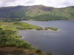
The lake occupies part of Borrowdale and lies immediately south of the town of Keswick. It is both fed and drained by the River Derwent. It measures approximately 3 miles (4.8 km) long by 1 mile (1.6 km) wide and is some 72 feet (22 m) deep. There are several islands within the lake, one of which is inhabited. Derwent Island House, an 18th-century residence, is a tenanted National Trust property open to the public on five days each year.
Derwentwater is a place of considerable scenic value. It is surrounded by hills (known locally as fells), and many of the slopes facing Derwentwater are extensively wooded. A regular passenger launch operates on the lake, taking passengers between various landing stages. There are seven lakeside marinas, the most popular stops being Keswick, Portinscale and the Lodore Falls, from which boats may be hired. Recreational walking is a major tourist activity in the area and there is an extensive network of footpaths in the hills and woods surrounding the lake.
The Keswick—Borrowdale road runs along the eastern shore of the lake and carries a regular bus service. There is a lesser, or unclassified, road along the western shore connecting the villages of Grange and Portinscale.
Derwentwater gave its name to the Earldom of Derwentwater.
The lake is believed to be the last remaining native habitat of the vendace (Coregonus vandesius) fish from the four originally known sites: Bassenthwaite Lake and Derwentwater in the Lake District, and the Castle Loch & Mill Loch in Lochmaben.
Derwentwater cruise and walk around derwentwater lake keswick lake district hd
Etymology
'Derwent' is " '(River) with oak trees', traditionally explained from Brit." (i.e.: Brythonic Celtic) " 'derwā' 'oak' plus suffixes, hence of the same origin as other English rivers named Derwent, Darwen, Darent and Dart...The river gave its name to Derwent Water (which was also known as the 'Lake of Derwent', 'Keswick Lake', or 'Keswick Water' in the 18th-19th centuries)...". Plus "OE 'wæter', with the meaning probably influenced by its ON relative 'vatn'."
Derwentwater's islands
There are numerous islands in Derwentwater, the largest being Derwent Island, Lord's Island, St Herbert's Island, Rampsholme Island, Park Neb, Otter Island, and Otterbield Island. St. Herbert's Island is named after a C. 7th priest hermit, St. Herbert of Derwentwater.
In popular culture
Star Wars Episode VII: The Force Awakens filmed on location at Derwentwater for the scene "Approach to Maz Kantana's Castle, Takodana".
The EP Three Songs (2011) by Robin Pecknold includes a song named "Derwentwater Stones".
A photograph taken at Derwentwater is used as the album art for Black Sands by Bonobo.