
Other name(s) Sunset Tunnel Route US 26 (Sunset Highway) Traffic 7200 (2010) Highest elevation 366 m Width 7.9 m | Opened 1940 Toll no Length 235 m Number of lanes 2 | |
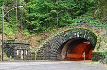 | ||
The Dennis L. Edwards Tunnel is a highway tunnel in northwestern Oregon that carries the Sunset Highway (U.S. Route 26) through the Northern Oregon Coast Range mountains near the unincorporated community of Manning, 27 miles (43 km) west of Portland. The tunnel was completed in 1940 and is 772.0 feet (235.3 m) long.
Map of Dennis L. Edwards Tunnel, Forest Grove, OR 97116, USA
The tunnel was originally known as the Sunset Tunnel until 2002. It was renamed in honor of Dennis L. Edwards, an Oregon Department of Transportation worker who was killed on January 28, 1999 when part of the tunnel collapsed while he was inspecting it for damage caused by heavy rains. The tunnel was closed for five weeks for repairs, and renamed for Edwards three years later.
References
Dennis L. Edwards Tunnel Wikipedia(Text) CC BY-SA