
Country United States Type of dam Earth-fill embankment Height 50 m Surface area 360.2 km² | Status Operational Opened 1944 | |
 | ||
Length 15,200 ft (4,633 m) (not including levees) Owner United States Army Corps of Engineers Similar Lake Texoma, Red River of the South, Eisenhower State Park, Eisenhower Birthplace State Hist, Lavon Dam | ||
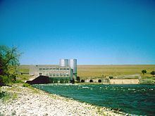
Denison Dam, also known as Lake Texoma Dam, is a dam located on the Red River between Texas and Oklahoma that impounds Lake Texoma. The purpose of the dam is flood control, water supply, hydroelectric power production, river regulation, navigation and recreation.
Contents
Map of Denison Dam, Cartwright, OK 74731, USA
History
Completed in 1943 primarily as a flood control project, it was at the time the "largest rolled-earth fill dam in the world". Only five times has the lake reached the dam's spillway at a height of 640 feet (200 m) above sea level: 1957, 1990, 2007, and twice in 2015. It takes its name from Denison, Texas, just downriver from the damface.
Denison Dam contains a total of 18.8 million cubic yards (14,000,000 m³) of rolled-earth fill. It produces roughly 250,000 megawatt hours of electricity per year, while Lake Texoma provides nearly 125,000 acre feet (154,000,000 m3) of water storage for local communities under five permanent contracts.
In addition to two federally managed wildlife-refuge areas, Denison Dam has made possible 47 recreational areas managed by the U.S. Army Corps of Engineers, two state parks -- one in Oklahoma and one in Texas -- as well as 80,000 acres (32,000 ha) of open public land used for hunting.
[...] General Lucius D. Clay was the principal manager of the project.