
Climate Cfb Area 877 km² | Region Marmara Region Website www.demirkoy.bel.tr Local time Monday 10:16 AM | |
 | ||
Weather 12°C, Wind S at 26 km/h, 74% Humidity | ||
Demirköy (Turkish: Demirköy, "iron village"; known as Малък Самоков, Malak Samokov in Bulgarian) is a town and district of Kırklareli Province in the Marmara region of Turkey. The inhabitants are mainly descendants of Muslims from the village of Tisovo and other villages from the Greek side of the Chech region who were settled in Demirköy during the population exchange between Greece and Turkey in 1923/1924. Prior to that, the village was known as Samakovo (Greek: Σαμάκοβο) or Samokov (Bulgarian: Самоков).
Contents
Map of Demirk%C3%B6y, K%C4%B1rklareli, Turkey
The mayor is Muhlis Yavuz (MHP). The population is 3,719 (as of 2010).
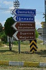
Visitor attractions
A historic metalworking faciliy dating back to the 15th century, the Demirköy Foundry (Turkish: Demirköy Dökümhanesi), currently an archaeological site, is located 3.8 km (2.4 mi) southeast of Demirköy.
The Dupnisa Cave (Turkish: Dupnisa Mağarası) is a show cave located deep in the Strandzha forests 25 km (16 mi) southwest of the town.
The İğneada Floodplain Forests National Park (Turkish: İğneada Longoz Ormanları Milli Parkı) is at 25 km (16 mi) east of Demirköy near İğneada. The Lake Saka Nature Reserve is situated inside the national park.