
Elevation 10,300 ft (3,100 m) Country United States Peak Mount Kimball | Length 95 mi (153 km) State/Province Alaska Mountains Mount Kimball | |
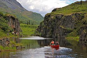 | ||
The Delta Mountains or Delta Range are a subrange of the Alaska Range, forming its eastern terminus. The mountains extend about 95 miles (153 km) from east to west, to the south of the Tanana River Valley, west of the Nebesna River and northwest of Wrangell-St. Elias National Park and the Copper River, and cover an area of 6,313 square miles (16,350 km2). The highest point of the range is Mount Kimball, at 10,300 feet (3,100 m).
The Delta River originates on the south side of the range, near Paxson, and flows north through the mountains (between the Delta Mountains and the Hayes Range, to the west) to join the Tanana River. It has been designated a National Wild and Scenic River since 1980.
References
Delta Mountains Wikipedia(Text) CC BY-SA