
Existed: 1936 – present Counties: Kent Constructed 1936 | Length 25.94 km | |
 | ||
Touristroutes: Harriet Tubman Underground Railroad Byway East end: DE 1 at Dover Air Force Base | ||
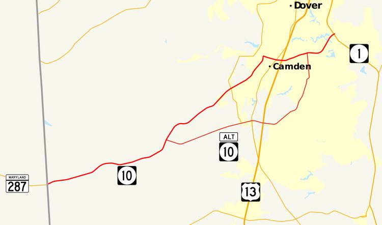
Delaware Route 10 (DE 10) is a state highway in Kent County, Delaware. It runs from Maryland Route 287 (MD 287) at the Maryland border in Sandtown east to an interchange with DE 1 at the north gate of Dover Air Force Base. The route passes through the towns of Camden and Wyoming along the way. From the Maryland border to Camden, it is a two-lane undivided road that passes through rural areas. DE 10 is a four-lane divided highway called Lebanon Road between U.S. Route 13 (US 13) in Camden and DE 1. DE 10 has one alternate route, DE 10 Alternate (DE 10 Alt.), which provides an alternate alignment between Willow Grove and Lebanon, passing through Woodside and Rising Sun.
Contents
- Map of DE 10 Delaware USA
- Route description
- History
- Major intersections
- Delaware Route 10 Alternate
- References
Map of DE-10, Delaware, USA
What is now DE 10 between the Maryland border and Camden was constructed as a state highway in stages in the 1920s and early 1930s. The route was first designated by 1936 to follow its current alignment between the Maryland border and Camden and current Rising Sun Road to US 113 Alt. in Rising Sun. By 1969, DE 10 was rerouted to follow Lebanon Road, a road completed by 1966, to US 113 (now DE 1) at Dover Air Force Base. Lebanon Road was improved into a divided highway by 1981.
Route description
DE 10 begins at the Maryland border west of Sandtown, where it continues west into that state as MD 287. From the state line the route heads east on two-lane undivided Willow Grove Road through a mix of farmland and woodland with some homes, passing through Sandtown. The road curves northeast and runs through Petersburg before coming to an intersection with the western terminus of DE 10 Alt. DE 10 passes the community of Willow Grove and continues northeast. The route heads through rural areas with increasing residential development and intersects DE 15 before crossing Norfolk Southern's Delmarva Secondary railroad line.
The road continues north into Camden and passes homes along with some businesses, becoming South Caesar Rodney Avenue at the South Street intersection. DE 10 forms the border between Wyoming to the west and Camden to the east before turning east onto East Camden Wyoming Avenue and fully entering Camden. The route continues through residential areas, intersecting US 13 Alt. in the center of Camden. On the eastern edge of Camden, the road comes to an intersection with US 13.
Past the intersection with US 13, DE 10 becomes Lebanon Road, a four-lane divided highway. The road heads east-northeast and passes through areas of suburban residential development to the south of Dover. The route comes to an intersection with South State Street, where DE 10 Alt. returns to the route. DE 10 runs east through a mix of residential and commercial development, curving to the northeast. The road crosses the St. Jones River and reaches an interchange with access to and from the southbound direction the DE 1 freeway. DE 10 comes to its eastern terminus within this interchange at an intersection with Bay Road at the north gate of Dover Air Force Base. Bay Road runs north to provide access to and from the northbound direction of DE 1.
The portion of the route between the Maryland border and US 13 Alt. in Camden and between DE 10 Alt. and Gateway South Boulevard near Lebanon is part of the Harriet Tubman Underground Railroad Byway, a Delaware Byway. DE 10 has an annual average daily traffic count ranging from a high of 22,770 vehicles at the eastern terminus at Bay Road to a low of 2,262 vehicles at the Sandtown Road intersection. None of DE 10 is part of the National Highway System.
History
By 1920 what is now DE 10 existed as an unimproved county road. The portion of the current route through Camden, as well as the road between Camden and Rising Sun, was upgraded to a state highway by 1924. By 1925 the road was completed as a state highway between Willow Grove and Camden, while the portion between the Maryland border near Sandtown and Willow Grove was under proposal as a state highway. The portion of road west of Willow Grove became a state highway by 1931. DE 10 was assigned to run from the Maryland border near Sandtown to US 113 Alt. (South State Street) in Rising Sun by 1936, following its current alignment between the Maryland border and Camden and Rising Sun Road between Camden and Rising Sun. By 1964, the route was realigned to bypass Willow Grove to the southeast, with the former alignment now Willow Tree Circle. The Lebanon Road portion of DE 10 was constructed by 1966, connecting the route east of Camden to US 113 (Bay Road) at Dover Air Force Base. DE 10 was rerouted to follow Lebanon Road to US 113 by 1969.
The Lebanon Road portion of the route between US 13 and US 113 was completely widened into a divided highway by 1981. In 1993, the DE 1 freeway was completed in the area of the eastern terminus, with an interchange to that road built that incorporated ramps to both DE 10 and the existing US 113, which merged with DE 1 at this point. The US 113 designation was removed from the area in 2004, leaving DE 10 terminating only with DE 1.
Major intersections
The entire route is in Kent County.
Delaware Route 10 Alternate
Delaware Route 10 Alternate (DE 10 Alt.) is an alternate route of DE 10 between Willow Grove and Lebanon. The route heads east from DE 10 on two-lane undivided Henry Cowgill Road, passing through a mix of farmland and woodland with some homes. DE 10 Alt. reaches Woodside and intersects DE 15, with that route becoming concurrent with DE 10 Alt on Main Street. The road crosses Norfolk Southern's Delmarva Secondary railroad line and becomes lined with homes. At an intersection with US 13 Alt., DE 15 splits from DE 10 Alt. by heading south of US 13 Alt. DE 10 Alt. leaves Woodside and becomes Walnut Shade Road, coming to an intersection with US 13. Past this intersection the route passes to the south of Polytech High School and enters a mix of farms, woods, and residential development, curving to the northeast. DE 10 Alt. reaches the community of Rising Sun, becoming Sorghum Mill Road at the Rising Sun Road intersection before turning north onto South State Street. The route passes through woods and runs through residential development before ending at another intersection with DE 10, with South State Street continuing north toward Dover.
The road was constructed as a state highway between Woodside and Rising Sun in 1931 and between Willow Grove and Woodside the following year. DE 10 Alt. was designated by 1988 onto its current alignment. Prior to 2004 the South State Street portion of DE 10 Alt. was concurrent with US 113 Alt., which was decommissioned when US 113 was truncated from Dover to Milford.
The entire route is in Kent County.