
Location Penobscot Bay, Maine Automated 1958 Tower shape Square tower Range 14,816 m Focal height 16 m Material Brick | Year first constructed 1857 Foundation Masonry Opened 1857 Current lens length 25 cm Construction Brick | |
 | ||
Markings / pattern White with black lantern and trim Similar Eagle Island Light, Great Duck Island Light Station, Crabtree Ledge Light, Franklin Island Light, Mount Desert Light Stati | ||
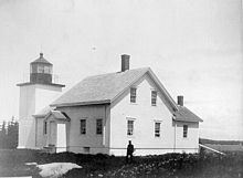
Deer Island Thorofare Light, also known as Mark Island Light, is a lighthouse on Penobscot Bay, Maine, about 1.8 nautical miles (3.3 km; 2.1 mi) west-southwest of Stonington. It was built in 1857.
Contents
History
The station was established in 1857 with the building of the current small square brick tower and a keeper's house. It was built at the time that the granite quarries on Deer Isle and Crotch Island, immediately to the east, were becoming important for the construction of public buildings throughout the eastern United States. It was automated in 1958. The keeper's house burned down in 1959 and the rest of the buildings were removed shortly thereafter. In 1998 control of the site was passed to the Island Heritage Trust, a local group which preserves historic sites in the area. They have promised to keep the island as a bird sanctuary.
Location and Nomenclature
It sits on a small island at the west end of the Deer Island Thorofare and of Merchant Row, two east-west passages among the small islands which lie between Deer Isle and Isle au Haut. The island is called "Mark Island" on NOAA charts 13302 and 13313, but "Marks Island" on the larger scale chart 13315. The light is called "Mark Island Light" on an early 20th-century postcard and is still locally referred to by that name. Also confusing is that the large island to the north and the town on it are "Deer Isle", but the passage is "Deer Island Thorofare".