
Length 10.5 mi (16.9 km) Use Hiking | Sight Teton Range | |
 | ||
Elevation change Approximate gain of 2,800 ft (850 m) Similar Teton Range, Phelps Lake, Death Canyon Shelf, Static Peak Divide, Static Peak | ||
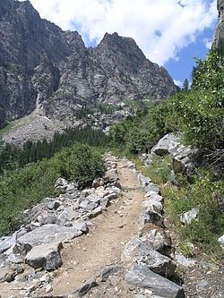
Death canyon trail grand teton national park
The Death Canyon Trail is a 10.5 mi (16.9 km) long hiking trail in Grand Teton National Park in the U.S. state of Wyoming. The trail begins west of the White Grass Ranger Station Historic District and ends at Fox Creek Pass where it intercepts the Teton Crest Trail. The trail follows the length of Death Canyon. To get to the trail, the Valley Trail must be accessed at the White Grass Grass Ranger Station then by trending westward just to the north of Phelps Lake. Near Phelps Lake Overlook, the Death Canyon Trail heads west and is flanked by Albright Peak to the north and Prospectors Mountain to the south. After over 2 mi (3.2 km), the canyon widens and is intercepted by the Alaska Basin Trail. The Death Canyon Trail continues west then southwest, climbing steadily to Fox Creek Pass. The camping zone in the canyon extends from just west of the Alaska Basin Trail junction to .5 mi (0.80 km) below Fox Creek Pass and is available by permit.