
Elevation 1,097 m Country United States of America | Length 11 mi (18 km) N-S Highest point Mount Manchester Mountains Mount Manchester | |
 | ||
Width 5 mi (8.0 km) E-W-(widest at north) Borders on Similar Sacramento Mountains, Chemehuevi Mountains, Stepladder Mountains, Bigelow Cholla Garden, Turtle Mountains | ||
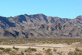
The Dead Mountains are a mountain range in the southeastern Mojave Desert, in San Bernardino County, California. The range borders the tri-state intersection of Nevada, Arizona and California, and the Mohave Valley, with the Fort Mojave Indian Reservation bordering the range foothills on the east and northeast, in the three states.
Contents
Map of Dead Mountains, California 92363, USA
GeographyEdit
The Dead Mountains are 12 miles (19 km) northwest of Needles, California. They border the Colorado River on the east, and the Piute Wash of the Piute Valley on the west. Piute wash drains south, then turns east for 8 mi at the south of the range to meet the Colorado River.
Mount Manchester is the highest point at 3,598 feet (1,097 m).
Dead Mountains WildernessEdit
The rust colored mountains, which cover 46,758 acres, were designated the Dead Mountains Wilderness in 1994 by the United States Congress. They are maintained by the Bureau of Land Management. The vegetation is mostly creosote bush and desert wash scrub. The California Desert Conservation Area is located within the wilderness and Smoke trees are found there.
The wildlife found on the mountains includes coyote, a small herd of bighorn sheep, rattlesnakes, falcons, hawks, eagles. A portion of the wilderness is critical habitat for the endangered Desert Tortoise.