
County-level divisions 4 districts3 counties Postal code 165000 Local time Saturday 10:39 PM Area code 0457 | Time zone China Standard (UTC+8) Area 83,000 km² | |
 | ||
Country People's Republic of China Township-level divisions 6 subdistricts24 towns11 townships2 ethnic townships Village-level divisions 41 residential communities80 villages Weather -19°C, Wind NW at 11 km/h, 64% Humidity Points of interest Da Hinggan Ling Five, Oroqen Nationality Museum, Qixiashan Botanical Garden, Shibazhan Paleolithic Site | ||
Daxing'anling Prefecture (Chinese: 大兴安岭地区; pinyin: Dàxīng'ānlǐng Dìqū), also known as Da Hinggan Ling Prefecture, is the northernmost Chinese prefecture-level division, located in Heilongjiang Province. Its area is 46,755 square kilometres (18,052 sq mi) and has a population of 520,000, as of 2004. It is named after the Greater Khingan Range (Daxing'anling; ᠠᠮᠪᠠ᠋ ᡥᡳᠨ᠋ᡤᡤᠠᠨ ᠵᡠᡨ᠊ᡠᠨ; Amba Hinggan Jutun) Mountains. In 2007 it had a GDP of RMB 6.1 billion and a growth rate of 11.1%. In 2015 Daxing'anling Prefecture had a GDP of RMB 13.49 billion, while a GDP of RMB 15.39 billion in the year 2014.
Contents
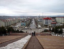
Map of Da Hinggan Ling, Heilongjiang, China
Administrative divisions
Daxing'anling Prefecture administrates 3 counties, 4 Forestry administration districts. These counties and management districts contain 6 urban subdistricts, 24 towns, 11 townships, 2 ethnic townships, 41 residential communities, and 80 villages.
Forestry divisions
Administrate by the State Forestry Administration's Heilongjiang Daxing'anling Forestry Group Corporation (Chinese: 黑龙江省大兴安岭林业集团公司) with 10 Forestry Bureaux and 61 Woodlands.
Administrate by Daxing'anling Prefecture Administrative Operation Forestry Bureau (Chinese: 大兴安岭地区行政公署营林局) with 3 County-level Forestry Bureaux and 6 Woodlands.