
Country United Kingdom | ||
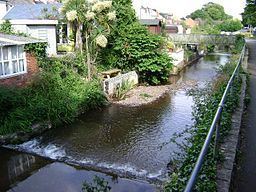 | ||
Dawlish Water is a minor coastal stream which flows through Devon, England.
Map of Dawlish Water, Dawlish, UK
It rises in Haldon Forest by the A380 road and flows southeast through Ashcombe to Dawlish flowing over a series of weirs, (this part of Dawlish is prone to flooding) through the centre of the town under the A379 road and the London to Penzance railway line before terminating in the English Channel.
The water level of the stream has been measured in Dawlish since 2012, normal levels are between 0.12 metres (4.7 in) and 0.33 metres (1 ft 1 in). The maximum recorded level was 1.32 metres (4 ft 4 in) in November 2012.
References
Dawlish Water Wikipedia(Text) CC BY-SA