
Country United States Area code(s) 304 Elevation 945 m Population 648 (2013) | Time zone Eastern (EST) (UTC-5) FIPS code 54-20428 Zip code 26260 Local time Saturday 7:42 AM | |
 | ||
Weather -11°C, Wind W at 16 km/h, 75% Humidity | ||
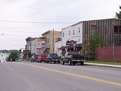
Davis is a town in Tucker County, West Virginia, along the Blackwater River. The population was 660 at the 2010 census.
Contents
- Map of Davis WV 26260 USA
- History
- Geography
- Mountain biking
- 2010 census
- 2000 census
- Notable native
- Climate
- References
Map of Davis, WV 26260, USA
History
Davis was named either for Senator Henry Gassaway Davis, or for his family generally.
The Herman August Meyer House was listed on the National Register of Historic Places in 2010.
Geography
Davis is located at 39°07′52″N 79°27′59″W (39.131110, -79.466318). It is located in the northern portion of the Canaan Valley, West Virginia near the Canaan Valley State Resort Park, and is partially surrounded by the Monongahela National Forest including scenic Blackwater Falls.
At an elevation of 3,100 feet, Davis has the highest elevation of any West Virginia town.
According to the United States Census Bureau, the town has a total area of 1.83 square miles (4.74 km2), all of it land.
Mountain biking
The area surrounding Davis is renowned for its mountain biking trails and bike culture. The most notable trails include the Plantation Trail, Hoo Doo Hustle and Moon Rocks. Many more miles of trails are also easily accessible at nearby Blackwater Falls State Park. The area also hosts several mountain bike races each year. One of these races, The Revenge Of The Rattlesnake, is considered one of the toughest bike races in the country.
2010 census
As of the census of 2010, there were 660 people, 305 households, and 173 families residing in the town. The population density was 360.7 inhabitants per square mile (139.3/km2). There were 425 housing units at an average density of 232.2 per square mile (89.7/km2). The racial makeup of the town was 98.0% White, 0.5% Native American, 0.5% from other races, and 1.1% from two or more races. Hispanic or Latino of any race were 0.9% of the population.
There were 305 households of which 20.0% had children under the age of 18 living with them, 43.6% were married couples living together, 9.2% had a female householder with no husband present, 3.9% had a male householder with no wife present, and 43.3% were non-families. 37.4% of all households were made up of individuals and 15.4% had someone living alone who was 65 years of age or older. The average household size was 2.16 and the average family size was 2.82.
The median age in the town was 46.1 years. 17.7% of residents were under the age of 18; 6.8% were between the ages of 18 and 24; 24.1% were from 25 to 44; 34.9% were from 45 to 64; and 16.5% were 65 years of age or older. The gender makeup of the town was 47.0% male and 53.0% female.
2000 census
As of the census of 2000, there were 624 people, 290 households, and 176 families residing in the town. The population density was 546.0 inhabitants per square mile (211.3/km2). There were 380 housing units at an average density of 332.5 per square mile (128.7/km2). The racial makeup of the town was 97.92% White, 0.16% Native American, and 1.92% from two or more races. Hispanic or Latino of any race were 0.32% of the population.
There were 290 households out of which 26.2% had children under the age of 18 living with them, 44.5% were married couples living together, 11.7% had a female householder with no husband present, and 39.3% were non-families. 36.9% of all households were made up of individuals and 20.0% had someone living alone who was 65 years of age or older. The average household size was 2.15 and the average family size was 2.76.
In the town, the population was spread out with 22.0% under the age of 18, 6.1% from 18 to 24, 26.6% from 25 to 44, 23.4% from 45 to 64, and 22.0% who were 65 years of age or older. The median age was 42 years. For every 100 females there were 84.6 males. For every 100 females age 18 and over, there were 88.0 males.
The median income for a household in the town was $25,221, and the median income for a family was $31,333. Males had a median income of $21,607 versus $17,250 for females. The per capita income for the town was $22,399. About 14.6% of families and 14.6% of the population were below the poverty line, including 19.4% of those under age 18 and 10.9% of those age 65 or over.
Notable native
Climate
The climate in this area has mild differences between highs and lows, and there is adequate rainfall year-round. According to the Köppen Climate Classification system, Davis has a marine west coast climate, abbreviated "Cfb" on climate maps.