
Country Armenia Time zone AMT (UTC+4) Elevation 2,050 m Marz province Syunik Province | First mentioned 12th century Area 50 ha Local time Saturday 6:08 AM | |
 | ||
Weather -8°C, Wind W at 5 km/h, 98% Humidity | ||
Dastakert (Armenian: Դաստակերտ), is a town and an urban community in the Syunik Province of Armenia. It is located at a distance of 236 km south of the capital Yerevan and 127 km north-west of the regional centre Kapan. With a population of 323 inhabitants (2011 census) and an area of 0.5 km², Dastakert is the smallest urban community of Armenia in terms of population and area.
Contents
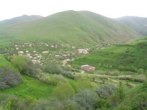
- Map of Dastakert 3509 Armenia
- Etymology
- History
- Geography
- Demographics
- Culture and education
- Transportation
- Economy
- References
Map of Dastakert 3509, Armenia
Etymology
Being founded as a summer resort for the monks of the nearby Tatev monastery, the name of the town was derived from the old Armenian word Dastakert (Armenian: Դաստակերտ), literally meaning summer resort or backyard.
History
Dastakert was first mentioned in history by Stepanos Orbelian in the 12-13th centuries as a small village, founded as a summer resort for the monks of the nearby Tatev monastery. According to the 2011 census the population of Dastakert was 323, up from 287 at the 2001 census.
During the Soviet period, Dastakert was granted the status of an urban-type settlement in 1951. In 1952 the Dastakert branch of the Zangezur copper-molybdenum plant was opened near the settlement. In 1968, during the Soviet heyday, there were around 4,000 residents in Dastakerd.
However, after the closure of the copper-molybdenum plant in 1975, the population has drastically declined, and all that remained from the town's boom period was only its status as an urban community. Currently, around 300 residents live in Dastakert. Most residents are Armenian refugees from Azerbaijan.
Geography
Dastakert is situated on the slopes of Mount Ayri of the Zangezur Range, near the roots of Ayri river (a tributary of Sisian river). At a height of 2050 meters above sea level, Dastakert is considered a mountainous settlement.
Historically, Dastakert was part of Tsghuk canton (Armenian: Ծղուկք գավառ Tsghukk gavar), at the heart of the ancient province of Syunik, within Armenia Major.
Demographics
Dastakert is the smallest town in Armenia and one of the smallest urban settlements in the world by population. The population of the town has significantly grown during the 1950s and 1960s after the opening of the Dastakert branch of Zangezur copper and molybdenum combine, exceeding the 4,000 residents. Starting from mid 1970s, the population has gradually declined with the closire of the plant. Currently, the population of Dastakert is around 300 who are entirely Armenians, with most of them are refugees from Azerbaijan. Between 2 and 3 children are born in Dastakerd on a yearly basis.
Here is the population timeline of Dastakert since 1908:
Culture and education
Dastakert has a secondary school, palace of culture, school of music and a public library ran by the municipality.
There is a lithographic inscription 2 km north of the settlement on a rock called Vardapet-Stone.
Transportation
Dastakert could be only reached through the regional H-44 Road that connects the town with Sisian at the north, near the Tolors reservoir.
Economy
In 1995, the government of independent Armenia, reaffirmed the status of Dastakert as an urban settlement within the Syunik Province. Economically, it is the poorest town in Armenia.
Most of the residents are involved in agriculture. However, only 8% of the town's residents have permanent jobs, mainly in the post office, the municipality and the school. A branch of the Zangezur Copper and Molybdenum Combine with its ore-dressing mill was opened on the basis of the old Soviet copper-molybdenum plant of Dastakert.