
Population 10,685 (Ward. 2011) Sovereign state United Kingdom | OS grid reference SE411048 Local time Friday 4:07 PM Dialling code 01226 | |
 | ||
Weather 6°C, Wind E at 13 km/h, 96% Humidity | ||
Darfield is a village within the Metropolitan Borough of Barnsley, South Yorkshire, England. Historically part of the West Riding of Yorkshire. The village is situated approximately 4 miles (6 km) east from Barnsley town centre. Darfield had a population of 8,066 at the 2001 UK Census, increasing to 10,685 at the 2011 Census.
Contents
Map of Darfield, UK
History
Roman coins have been unearthed in Darfield, and there is evidence to suggest that the village contained Roman habitation during its history.
In Saxon, the name "Feld" describes 'a large area of pasture land' , while the term "Dere" refers to the deer which inhabited the forest. When combined, this gives the name Derefeld which later became Darfield.
There are records of an 8th-century church in Darfield, but when the Domesday Book was written in 1086 there was no mention of it.
Darfield remained an insignificant agricultural village for many centuries to come, until 1862. In that year, two mining companies sank shafts in the Barnsley district to exploit the rich seam of coal running through the area. Darfield Main colliery and Mitchell's Main were local mines, the population of the village quickly increased and it became a labour pool for the surrounding coalmines. By 1901, over 4,000 people lived there compared to just 600 inhabitants in 1851.
Until June 1963, Darfield had a railway station on the former Midland Railway's Sheffield Midland - Cudworth - Leeds City line. The line itself closed in 1988 due to severe subsidence.
Community
Darfield shops include a Co-op supermarket, a florist's, baker's, newsagent's, two hairdresser's, garage/MOT station, a post office, greetings card shop, and a hardware & homeware shop. Two village chemists are based inside the local doctors' surgery and on Snape Hill Road. Food outlets include two Indian restaurants (formally The Bridge Inn and The Station public house) two takeaway cafes, two fish and chip shops, a Chinese takeaway and a pizzeria.
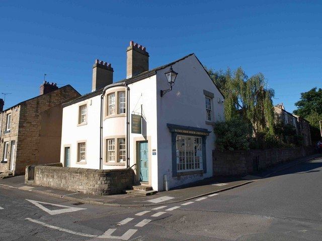
Darfield is the home to the Maurice Dobson museum which is divided into four parts: the main museum, an outlet area where local people can sell their craft items, a cafe/gallery, and a meeting place. There is also an outdoor patio where some larger items are exhibited. The museum's property was donated to the village by Maurice Dobson, after whom the museum is named. There is also a small village public library. Religion is served by an Anglican parish church and two Methodist chapels.
Transport
Stagecoach Yorkshire operate bus services every 15 minutes to Barnsley during the daytime as well as 2 buses per hour to Wombwell. Darfield is also served by the express bus service X19 which operates direct to Doncaster and Robin Hood Airport. Also, both Wombwell and Goldthorpe railway stations are within easy reach of Darfield where connections can be made to Sheffield, Meadowhall, Wakefield and Leeds.
Education
Darfield schools include:
Sport
Darfield has a cricket club which plays at Darfield Cricket Ground and a junior football team which is Darfield JFC, they have played on the Longbow playing fields former Darfield Foulstone School Fields for the last 21 years.
The village has had a team play in the FA Cup before - Darfield F.C. Its nearest professional football club is Barnsley F.C. based in the city centre of the metropolitan borough.
Notable people
Steven Lancaster. Chemist and one of the Royal Society of Chemistry's 175 'Faces of Chemistry.