
Sub-provincial city Harbin Time zone China Standard (UTC+8) Population 923,762 (2010) Area code 0451 | Elevation 130 m (430 ft) Area 479.2 km² Province Heilongjiang | |
 | ||
Country People's Republic of China Subdivisions 18 subdistricts
4 towns
1 township Harbin district map 1
2
3
4
5
6
Shuangcheng
Hulan
Bayan
County
Mulan
County
Tonghe
County
Yilan
County
Bin
County
Fangzheng
County
Acheng
Yanshou
County
Shangzhi
(city)
Wuchang
(city)
1. Daoli
2. Daowai
3. Songbei
4. Nangang
5. Pingfang
6. Xiangfang | ||
Daoli District (simplified Chinese: 道里区; traditional Chinese: 道里區; pinyin: Dàolǐ Qū) is one of nine districts of Harbin, the capital of Heilongjiang province, People's Republic of China, forming part of the city's urban core. It is located on the Songhua River. It borders the districts of Songbei to the north, Daowai to the northeast, Nangang to the east, and Shuangcheng to the south, as well as the prefecture-level city of Suihua to the northwest.
Contents
Map of Daoli, Harbin, Heilongjiang, China
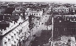
Nowadays, Daoli District is also famous because of Central Street (中央大街; Zhōngyāng Dàjiē; Russian: Китайская улица), which is one of the main business streets in Harbin.
Administrative divisions
There are 18 subdistricts, four town, and one township in the district:
Towns (镇)
Township (乡)
References
Daoli District Wikipedia(Text) CC BY-SA