
Administrative divisions 2 eup, 6 myeon Population 37,320 (2002) | Area 781.1 km² | |
 | ||
Province | ||
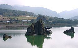
Danyang County (Danyang-gun) is a county in North Chungcheong Province, South Korea.
Contents
- Map of Danyang gun Chungcheongbuk do South Korea
- Paragliding danyang south korea gopro video
- Symbols
- Geography
- Climate
- Tourism
- Twin towns Sister cities
- References
Map of Danyang-gun, Chungcheongbuk-do, South Korea
Paragliding danyang south korea gopro video
Symbols
Geography
The geographical terrain is 83.7% mountainous and 11.2% cultivable. It is very rugged, except in some of the urban areas and villages that can be found in the valleys and hills. The main water system ranges from the upper stream of the 23.7 km long Namhan River, which flows through the county. Pyeongchang River, one of the streams flowing from Odaesan, joins several streams at Jungnyeong, Danyang, and Geumgok, originating from Sobaeksan. Danyang Stream, which has its source in Hakseongsan, Gyeongsangbuk-do, joins the Namhan River at Habang-ri, Danseong-myeon, together with Jungnyeong Stream flowing from Jungnyeong and Dosolsan to Hyeoncholli, Danyang-eup, Maepo Stream from Geumsusan to Dodam, and Geumgok Stream from Biro Peak to Gosu-ri, Danyang-eup.
Climate
The county, which is situated in an inland mountainous area, epitomizes an inland climate with severe variations in temperatures. The annual average temperature reaches 11.2 °C (52.2 °F), with the highest at 17.7 °C (63.9 °F) and the lowest at 5.6 °C (42.1 °F), and its annual rainfall averages 1,195.8 mm (47.1 in).
Tourism
Twin towns – Sister cities
Danyang is twinned with: