
 | ||
Danger Island is the westernmost and the southernmost island of the Great Chagos Bank, which is the world's largest coral atoll structure, located in the Chagos Archipelago in the Indian Ocean.
Contents
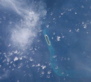
Map of Danger Island, British Indian Ocean Territory
Description
It is a 2 km (1.24 m) long and flat island with a maximum width of 400 m (1,312 ft), covered with tall coconut trees. Its name in all likelihood derives from the lack of a safe anchorage, which rendered every visit to this island dangerous for the ship and crew. The closest land is Île Vache Marine, the southernmost of the Eagle Islands which lies 16 km (10 mi) to the NNE.
History
There was never a permanent settlement on Danger Island, even at the time that the Chagos were inhabited (between the mid-18th and mid-20th centuries). However, occasionally plantation workers from other islands would be brought to this island to collect coconuts.
In 1975 there was an expedition to Danger Island by the Joint Services (JSDI). The expedition members were taken by RFA Resurgent to Eagle Islands and then by ketch and inflatable craft to Danger Island and to Three Brothers. The expedition made a topographical survey of the coral reef, an ecological survey of the corals on it and a study on the metabolism of the reef. A reference collection of samples of the flora and fauna of the area was also undertaken.
Following the Strict Nature Reserves Regulations issued on 18 September 1998, Danger Island, including its territorial waters and the reef surrounding it became a Strict Nature Reserve.
Danger Island has also been identified as an Important Bird Area by BirdLife International. Birds for which the island is of conservation significance include red-footed boobies (3,500 breeding pairs) and brown noddies (11,000 pairs).