
Country Thailand Tambon 10 Time zone ICT (UTC+7) Area 1,732 km² Province Loei Province | Seat Dan Sai Muban 99 Postal code 42120 Population 51,564 (2015) | |
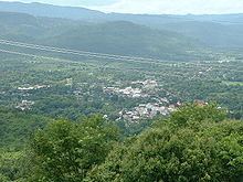 | ||
Dan Sai (Thai: ด่านซ้าย; [dàːn sáːj]) is a district (amphoe) in the western part of Loei Province, northeastern Thailand.
Contents
Map of Dan Sai District, Loei, Thailand
Geography
Neighboring districts are (from the east clockwise) Phu Ruea of Loei Province, Lom Kao and Khao Kho of Phetchabun Province, Nakhon Thai of Phitsanulok Province, and Na Haeo of Loei again. To the north is the Xaignabouli Province of Laos.
The source of the Pa Sak River is in the mountains in the eastern part of the district. A big part of the district is part of the Phu Hin Rong Kla National Park. Phu Thap Buek, the highest mountain of the Phetchabun Range, is at the southern end of the district. To the southeast is the Phu Luang Wildlife Sanctuary.
The northern part of the district reaches the southern end of the Luang Prabang Range mountain area of the Thai highlands.
Central administration
Dan Sai is divided into 10 sub-districts (Tambon), which are further subdivided into 99 administrative villages (Muban).
Local administration
There are two sub-district municipalities (Thesaban Tambon) in the district:
There are nine sub-district administrative organizations (SAO) in the district: