
Elevation 1,470 m Local time Thursday 9:31 AM Number of airports 1 | Time zone UTC + 8 (UTC+8) Population 18,700 (2010) | |
 | ||
Weather -6°C, Wind W at 6 km/h, 48% Humidity | ||
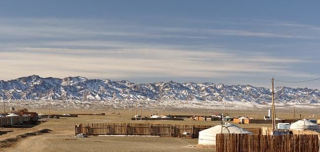
Dalanzadgad mongolia gobi desert adventure visit mongolia mongolia
Dalanzadgad (Mongolian: Даланзадгад; ᠳᠠᠯᠠᠨᠵᠠᠳᠠᠭᠠᠳ) is the capital of Ömnögovi Aimag in Mongolia. It is located 540 kilometers (340 mi) south of the national capital Ulaanbaatar. The altitude of the city center is 1,470 meters (4,823 feet).
Contents
- Dalanzadgad mongolia gobi desert adventure visit mongolia mongolia
- Map of Dalanzadgad Mongolia
- Transportation
- Climate
- Communications and Power
- References
Map of Dalanzadgad, Mongolia
As of 2006, its population is 14,000.
Transportation
The Dalanzadgad Airport (ZMDZ/DLZ) is served by regular domestic flights from and to Ulaanbaatar. There are summer and winter timetables.
In 2007 the Mongolian Civil Aviation Authority built a new airport with a paved runway. The runway is second longest in the country after Chinggis Khaan International Airport. Before that, the airport had only one gravel runway.
The Dalanzadgad town has a paved road connecting it with capital Ulaanbaatar city.
Climate
Dalanzadgad experiences a cold desert climate (Köppen BWk) with cold winters and hot summers. By Mongolian standards it is one of the warmest places in the country during winter. Along with Tsetserleg and Arvaikheer it was warmer than Hohhot in January 2014 and 2015. A unique steppe micro-climate with running streams and lush grass can be found in the nearby Yolyn Am valley.
Communications and Power
There is GSM coverage in the city the same as in other major locations - the coverage is good for about a mile out of the city. Usually, the city is also supplied with electric power 24 hours a day. Near Dalanzadgad, at 43°31′54.38″N 104°24′4.16″E, there is a longwave broadcasting station working on 209 kHz with 75 kW.