
Country United States County Tallapoosa FIPS code 01-19336 Elevation 222 m Zip code 36853 Population 3,186 (2013) | Time zone Central (CST) (UTC-6) GNIS feature ID 0117010 Area 41.4 km² Local time Wednesday 12:27 PM Area code 256 | |
 | ||
Weather 21°C, Wind N at 14 km/h, 21% Humidity | ||
Dadeville alabama traffic ticket attorney speeding ticket lawyer dadeville al
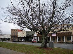
Dadeville is a city in Tallapoosa County, Alabama, United States. At the 2010 census the population was 3,230, up from 3,212 in 2000. The city is the county seat of Tallapoosa County.
Contents
- Dadeville alabama traffic ticket attorney speeding ticket lawyer dadeville al
- Map of Dadeville AL USA
- Help dadeville alabama traffic speeding ticket lawyer best dadeville al traffic attorney
- History
- Geography
- Climate
- Demographics
- 2010 census
- Government and infrastructure
- Notable people
- References
Map of Dadeville, AL, USA
Help dadeville alabama traffic speeding ticket lawyer best dadeville al traffic attorney
History
Dadeville was named for Major Francis Langhorne Dade, who died in the Seminole War in Florida in 1835. The town was granted a charter in 1837 and was first incorporated in 1858. It lost its charter during the Civil War, and was incorporated a second time in 1878. Dadeville has been the Tallapoosa County seat since 1838.
Dadeville was home to the Graefenberg Medical Institute, Alabama's first medical school, which operated from 1852 until the outbreak of the Civil War. Attempts to revive the school after the war failed, and the building burned in 1873.
Completion of the Thomas Wesley Martin Dam on the Tallapoosa River in 1926 and the subsequent creation of Lake Martin had and continues to have a strong economic impact on Dadeville.
Wickles Pickles is based in Dadeville.
Geography
Dadeville is located at 32°49′55″N 85°45′51″W (32.832059, -85.764288).
According to the U.S. Census Bureau, the city has a total area of 16.0 square miles (41 km2), all land.
Climate
The climate in this area is characterized by hot, humid summers and generally mild to cool winters. According to the Köppen Climate Classification system, Dadeville has a humid subtropical climate, abbreviated "Cfa" on climate maps.
Demographics
As of the census of 2000, there were 3,212 people, 1,122 households, and 813 families residing in the city. The population density was 200.7 people per square mile (77.5/km2). There were 1,278 housing units at an average density of 79.9 per square mile (30.8/km2). The racial makeup of the city was 53.24% White, 45.08% Black or African American, 0.25% Native American, 0.28% Asian, 0.37% from other races, and 0.78% from two or more races. 0.81% of the population were Hispanic or Latino of any race.
There were 1,122 households out of which 34.9% had children under the age of 18 living with them, 45.2% were married couples living together, 22.9% had a female householder with no husband present, and 27.5% were non-families. 24.8% of all households were made up of individuals and 10.5% had someone living alone who was 65 years of age or older. The average household size was 2.57 and the average family size was 3.05.
In the city, the population was spread out with 25.4% under the age of 18, 8.7% from 18 to 24, 26.7% from 25 to 44, 20.5% from 45 to 64, and 18.7% who were 65 years of age or older. The median age was 38 years. For every 100 females there were 85.3 males. For every 100 females age 18 and over, there were 81.0 males.
The median income for a household in the city was $25,266, and the median income for a family was $31,512. Males had a median income of $24,500 versus $20,781 for females. The per capita income for the city was $14,178. About 18.1% of families and 19.3% of the population were below the poverty line, including 25.6% of those under age 18 and 21.7% of those age 65 or over.
2010 census
As of the census of 2010, there were 3,230 people, 1,217 households, and 807 families residing in the city. The population density was 201.9 people per square mile (78.0/km2). There were 1,402 housing units at an average density of 87.6 per square mile (33.9/km2). The racial makeup of the city was 50.2% White, 47.5% Black or African American, 0.3% Native American, 0.6% Asian, 0.3% from other races, and 1.1% from two or more races. 0.9% of the population were Hispanic or Latino of any race.
There were 1,217 households out of which 27.6% had children under the age of 18 living with them, 38.5% were married couples living together, 23.3% had a female householder with no husband present, and 33.7% were non-families. 30.6% of all households were made up of individuals and 13.2% had someone living alone who was 65 years of age or older. The average household size was 2.45 and the average family size was 3.05.
In the city, the population was spread out with 22.9% under the age of 18, 9.6% from 18 to 24, 23.9% from 25 to 44, 27.0% from 45 to 64, and 16.6% who were 65 years of age or older. The median age was 39.9 years. For every 100 females there were 88.4 males. For every 100 females age 18 and over, there were 94.5 males.
The median income for a household in the city was $35,319, and the median income for a family was $38,824. Males had a median income of $32,031 versus $24,965 for females. The per capita income for the city was $15,923. About 16.9% of families and 19.4% of the population were below the poverty line, including 27.9% of those under age 18 and 15.2% of those age 65 or over.
Government and infrastructure
In 2015 members of the city council proposed an ordinance banning sagging shorts, and later proposed one banning miniskirts and short shorts.