
Country Turkey District Çağlayancerit Time zone EET (UTC+2) | Province Kahramanmaraş Province Elevation 930 m (3,050 ft) | |
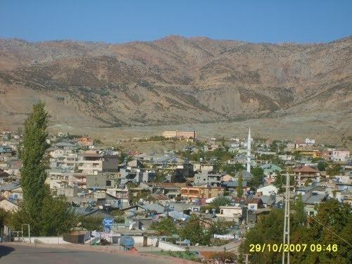 | ||
Düzbağ is a town in Kahramanmaraş Province, Turkey
Contents
- Map of DC3BCzbaC49F Helete Mahallesi 46780 C387aC49Flayancerit2FKahramanmaraC59F Turkey
- Geography
- History
- Economy
- References
Map of D%C3%BCzba%C4%9F, Helete Mahallesi, 46780 %C3%87a%C4%9Flayancerit%2FKahramanmara%C5%9F, Turkey
Geography
Düzbağ is in the rural area of Çağlayancerit which is a part of Kahramanmaraş Province. The coordinates of the town are 37°47′35″N 37°28′10″E. The town is situated at the southern foothill of a mountain. The altitude of the midtown is 930 metres (3,050 ft). The highway distance to Çağlayancerit is 17 kilometres (11 mi) and to Kahramanmaraş is 117 kilometres (73 mi). The population was 6,032 in 2009.
History
No record survives from 15th century when the settlement was a part of Dulkadirids. The settlement was annexed by the Ottoman Empire during the reign of Selim I in 1517. According to a census soon after the annexation, the name of the village was shown as Helete and the population of Helete was found out to be 200. In 1968 the village was declared a township named Düzbağ.
Economy
The traditional economic activity is animal husbandry. The main agricultural crops are fruits, especially grapes and apples. There is also a small carpet weaving factory. Since the 1960s Düzbağ residents who migrated to Germany as industrial workers (gastarbeiter) have also contributed to the town's economy.