
Formed January 1, 2014 Lowest pressure 945 mb (27.9 inHg) | Dissipated January 6, 2014 Damage €75 million | |
 | ||
Type Extratropical cyclone, Winter storm Areas affected Republic of Ireland, United Kingdom, France, Channel Islands, Isle of Man, Spain, Portugal | ||
Anne and Christina were two winter storms that affected western Europe in early January 2014. The storms brought storm surges along the coasts of France, Ireland and the United Kingdom on high spring tides a month after Cyclone Xaver brought surges during the previous peak tides to northern Europe.
Contents
Meteorological history
The low pressure was named Anne by the Free University of Berlin on 1 January. Some media referred to Anne as the "Moon Storm".
Storm surge
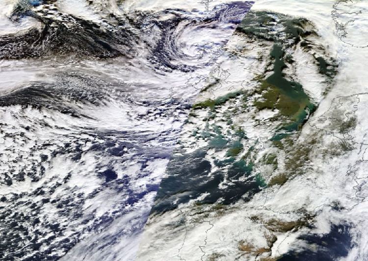
The Anne storm was deepened by the powerful jet stream, one of a series of lows which deepened below 950hPa (for every 1hPa drop in atmospheric pressure, sea level goes up by 1 cm) which is capable of adding over half a meter to sea levels. The storm coincided with high spring tides, and high discharge levels in rivers and estuaries. The long fetch of winds over the western Atlantic pushed water against the coasts, and helped to develop some significant wave heights, especially where the coastal morphology acts to funnel the waves.
Forecast
Meteo France issued an orange alert in Brittany for the departments of Morbihan and Ille-et-Vilaine, the warning level was raised to red for the department of Finistère. The Jersey Met Office gave out a red alert, their highest level of warning.
In the UK the Environment Secretary Owen Paterson said the country was facing "exceptional weather" after chairing a Cobra meeting on 2 January. Cork City Council warned of coastal flood threat in low-lying areas of the city.
The Isle of Man Government issued a red warning (the highest) for Friday 3 January, advising that water levels were expected to be 800mm above harbour walls. Water heights were expected to be higher than a surge event in 2002, which caused 8 million pounds of damage on the island. They warned islanders of the danger posed by contaminated water and open manhole covers, and announced the closure of vulnerable roads around the island.
Natural Resources Wales advised that they were expecting the highest tide to hit the entire Welsh coast since 1997.
Scottish Environment Protection Agency issued warnings on 2 January for coastal flooding on the west coast. They did not initially put out a flood alert for Stornoway, in the Western Isles but later issued one.
Coastal warnings were also in place along the north Spanish and Portuguese west coasts on 3 January.
Impact
The Channel Islands saw wind gusts reach 87 miles per hour (140 km/h) on Alderney, with gusts of 75 miles per hour (121 km/h) in Jersey.
The storm brought heavy showers, with reports of large hail and lightning strikes causing damage. A thunder storm in Exeter knocked out some traffic lights in the city. Lightning strikes were also responsible for stopping all rail transport in and out of Cornwall as signalling equipment was damaged near to Liskeard on 3 January. In Aylesbury 4 families were evacuated from their block of flats after the building was hit by lightning. Hail larger than a one pence coin (20mm diameter) was reported in Somerset, and mammatus cloud on the south coast of England in Bognor Regis.
The sea front of Exmouth was closed after a number of trees fell.
Numerous sporting fixtures were disrupted in the United Kingdom.
Saturated ground and heavy seas led to a section of cliff to collapse at Rock-a-Nore, near Hastings, East Sussex, which was filmed.
Storm surge
Coastal areas from Brittany to Scotland along the south and west coasts of Britain saw high seas. In Ireland coastal flooding was worst in the south and west of the country, but some flooding was noted on all coasts.
In France, Quimperlé, Finistere flooded again, after previously flooding during Cyclone Dirk in December 2013. Flooding was also reported in Morlaix and Quimper. 10,000 homes were left without power in north west France.
Coastal flooding was expected to be worst in the South West of England in Cornwall and Devon. The Environment Agency estimated that 130 homes had been flooded in England, with flood defences serving to protect 130,000 properties.
Devon County Council reported 35 homes and businesses flooded, with Lynmouth, Bishops Tawton, Bideford, East-the-Water on the north coast, and Dartmouth and Salcombe on the south coast worst affected.
In Looe flooding subsided by 10:30am as the tide lowered on 3 January. Polperro and Mevagissey were also reported as having some flooding.
At Portreath a section of the quay was washed away. Further along the north Cornish coast at Perranporth saw some flooding on the morning 3 January. Newquay saw part of Beach Road in resort collapse. At Porthcothan stormy seas caused a Natural arch to collapse.
In Bristol the Portway which runs by the River Avon was partially blocked with debris. Also in the city the Cumberland Basin flooded with new temporary flood barriers erected for the first time to protect housing.
The Severn bore combined with high water leading to flooding in Gloucestershire, as the river burst its banks at Minsterworth, Maisemore, Elmore and Newnham.
Widespread coastal flooding and damage occurred in Ireland. Flooding was reported in Cork and County Cork. Flooding began in Cork on 2 January evening tide at 17:45. Clare County Council described the promenade at Lahinch as "seriously compromised" following the storm. Images of waves lashing the promenade and spray blowing over the normally popular surfing location, were captured. Several families were evacuated from homes in the village after homes flooded. There were further reports of damage across County Clare in Doolin, Spanish Point and Quilty. Inishbofin in County Galway saw heavy seas, which caused extensive damage on the island, including a lighthouse beacon swept off its foundations.
In Northern Ireland parts of Coleraine in County Londonderry were flooded after the River Bann overflowed, several coastal roads around the region were closed because of flooding.
The Isle of Man Government said low-lying port areas were affected, with parts of Ramsey losing electricity, though damage appeared minimal.
In Wales 30 homes were flooded in Cardigan.
On the Welsh coast 100 residents were evacuated from vulnerable homes in Borth and Aberystwyth. Aberystwyth was hit by destructive high waves for the second time this winter, after it was hit by a storm which followed the St. Jude storm on the 2–3 November 2013. Aberystwyth sea front has previously been severely damaged by storms in October 1927 and January 1938.
Damage occurred to sea defences and gardens at St Bees, Cumbria.
In Scotland Dumfries and Galloway Council reported homes flooded on the Solway Firth at Annan, Powfoot and Carsethorn. Also homes along the coast in Kirkcudbright, Garlieston, the Isle of Whithorn, Port William and Portpatrick.
Inland flooding
The Somerset levels saw an increase in water levels, with the Environment Agency bringing in extra pumps to try and manage the water on the flooded moors, which was being hampered as the Agency had to wait for river levels to drop. All major roads into Yeovil were cut off by flood waters on the 4 January, with police advising against all travel to the town after the A37 and A359 became impassable.
Aftermath
The storm's impacts came on the day when the British Government announced that the Environment Agency in the UK would shed 1500 jobs (approximately a tenth of its staff) political questions were raised about the ability of the Agency to deal with future floods. The Government said it was spending more than the previous administration. Initial assessments by Irish local authorities put damage in millions of euros. Aberystwyth University asked students (many of whom were still on Christmas holiday) to not return until after midweek the next week, with fears of further damage from winter storm Christina.
Two trains were trapped at Barmouth, after 300 tonnes of track bed on the Cambrian Coast Line was washed away, depositing 800 tonnes of debris on the line causing its closure between Barmouth and Pwllheli at Llanaber. The trains were eventually moved to Chester by road.
Christina
The storm was more commonly referred to as Christine in Ireland. It was named Christina by the Free University Berlin on 3 January.
Meteorological synopsis
Christina began as an area of low pressure responsible for a winter storm in the United States and Canada, unofficially named Hercules by The Weather Channel, a name which was also used in several European newspapers. The low explosively deepened before moving out over the Atlantic. A Met Office spokeswoman said the storm developing in the Atlantic was "loosely connected to the weather system that caused the U.S. winter storm", explaining that as it moved over the Atlantic it would pick up moisture and warmth from the ocean which would change its character.
Ireland
Christina affected Ireland on the 175 anniversary of one of the worst storms of the last 500 years in the country, the Night of the Big Wind of 6 January 1839. The Irish Marine Institute recorded waves nearly 12 metres on 6 January on its M6 buoy on the Porcupine Bank off the north-west of Ireland, and off the coast of Belmullet, Co. Mayo.
Galway city saw coastal flooding along the coast at Spanish Arch, the Fishmarket and Docks, with Grattan road closed. Salthill Promenade and Seapoint in the city were closed. In Galway the River Corrib burst its banks near to Spanish Arch, but saw no major flooding. Junior Minister Brian Hayes said Galway's application for flood relief funding from the Office of Public Works would be dealt with rapidly.
A shipwreck featured in the opening credits of the comedy series Father Ted, the MV Plassey ship on Inis Oirr was damaged and moved for the first time since 1991 by the storm. The smallest of the Aran islands also bore the brunt of the storm, where the high seas pounded the coast and the lighthouse was damaged.
In County Clare "Christina" caused widespread damage, not due to high winds but due to high swells. Damage was reported from Loop Head, while the seafront in Lahinch and Liscannor was again severely hit. Road flooding due to swells was reported from Clahane, Doolin, Ballyvaughan, Doonbeg, Kilbaha and Carrigaholt.
At Rhosbeigh County Kerry the storm unearthed and moved the shipwreck of the Schooner Sunbeam buried since 1903, which was scheduled to be reburied by the National Monuments Service.
Aftermath
Initial estimates of the costs of repair in Ireland estimated that the total bill to local authorities could exceed €100m.
Clare County Council, thought to be the worst hit area, estimated costs for remedial work will cost €23.7 million. The county manager told the council in an emergency meeting the bill was beyond the financial capability of the council. Initial assessments by Kerry County Council estimated damage to infrastructure at €3.5 million, with an additional €16 million cost for coastal protection works. Estimates from Waterford were at €7 million, Cork County €5 million, Dublin City Council €100,000 and Galway City €1.5million (in the city only). Galway County, Donegal, Mayo, Sligo and Wexford were yet to release initial cost assessments.
The combined costs to Clare and Kerry councils was estimated at €46 million, with €5.8 million costs in the village of Lahinch alone.