
Formed 1 January 1998 Fatalities 2 total Affected areas Vanuatu, Solomon Islands | Dissipated 25 January 1998 Highest winds 165 km/h | |
 | ||
Lowest pressure 940 hPa (mbar); 27.76 inHg Damage $8.66 million (1998 USD) Areas affected Solomon Islands, Vanuatu, Northern Australia Date 1 January 1998 – 25 January 1998 Similar Cyclone Herbie, Cyclone Gwenda, Cyclone Magda, Cyclone Harvey, Cyclone Kathy | ||
The full life of cyclone katrina victor cindy 1997 1998 hd movie
Severe Tropical Cyclone Katrina was a long-lived and erratic tropical cyclone, which moved around Australia during parts of January and February 1998. The initial system developed on 2 January and meandered within the Coral Sea between the Queensland coast and Vanuatu for the next three weeks. After its decay the remnants of Katrina moved westward over Cape York Peninsula, past the Northern Territory and into the Indian Ocean.
Contents
- The full life of cyclone katrina victor cindy 1997 1998 hd movie
- Meteorological history
- Impact
- Vanuatu
- Australia
- References
Meteorological history
During 1 January, the Australian Bureau of Meteorology (BoM) started to monitor a tropical low, that had developed within the monsoon trough about 630 km (390 mi) to the east-northeast of Cairns in Queensland, Australia. During that day the system moved south-eastwards, before it entered an area of weak steering flow, which made the system perform a small cyclonic loop over the next two days. Early on 3 January the United States Joint Typhoon Warning Center initiated advisories on the system and designated it as Tropical Cyclone 12P. This was after the system had rapidly intensified and a wind report of 57 km/h (35 mph) had been received from Lihou Reef. At around the same time the BoM named the system Katrina, as it had become a Category 1 tropical cyclone on the Australian tropical cyclone intensity scale. After the system was named an increase in the deep westerly flow to the north of the system, caused Katrina to start moving north-eastwards towards the South Pacific basin. Over the next few days the system slowly intensified further as the systems inflow, was dominated by Cyclone Susan which was rapidly intensifying to the west of Vanuatu. Susan's outflow also caused a moderate amount of vertical wind shear over Katrina, which helped to inhibit development of the system and weakened it slightly.
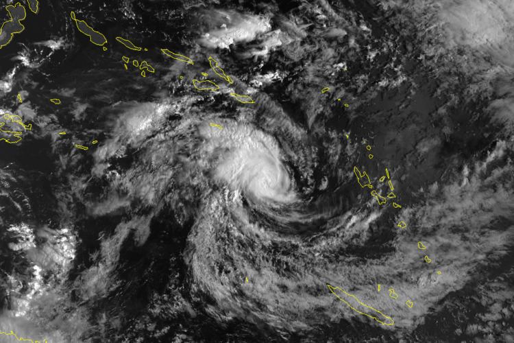
Katrina crossed 160°E and moved into the South Pacific basin during 7 January where it was monitored by the Fiji Meteorological Service, as it passed about 90 km (55 mi) to the south of Rennell Island in the Solomon Islands. The system subsequently started move south-eastwards towards the island nation of Vanuatu, as started to intensify quicker as Susan moved south-eastwards towards Fiji. The system subsequently came to within 220 km (135 mi) of Vanuatu's northernmost island Espiritu Santo, before it recurved westwards during 9 January, because of a weakening of the monsoonal westerlies and the development of an anticyclone to the south of the system. Later that day the FMS reported that the system had peaked as a Category 3 severe tropical cyclone, on the Australian scale with 10-minute sustained wind speeds of 150 km/h (90 mph). The JTWC also reported during 9 January that the system had peaked with 1-minute sustained wind speeds of 165 km/h (105 mph), which made the system equivalent to a category 2 hurricane on the Saffir-Simpson hurricane wind scale.
On 11 January, Katrina moved south of Rennell Island and then crossed back into the Brisbane area six hours later where it crossed the 160E on its eastward journey, then the storm turned west where it maintained that course until 15 January. On the 15th, the storm moved south-southwest where it reached Saffir–Simpson Hurricane Scale Category 2 strength with a barometric pressure of 940 mbar. Katrina weakened rapidly and slowed before making a tight loop on 17 and 18 January. After completing the loop, Cyclone Katrina moved east for 12 hours before moving east-southeast for three days. During that time, Katrina briefly reached Category 1 strength once more before slowing down and being affected by wind shear. By 24 January, Katrina had weakened to a tropical depression. Over the next few days Katrina's remnant low moved south-westwards before turning northwestwards during 28 January. The system was last noted by the JTWC on 2 February just off the Cape York Peninsula.
Katrina's remnants continued passing across northern Cape York Peninsula, until it reformed on 8 February and became Cyclone Victor, later dubbed Cindy by Mauritius Meteorological Service. It persisted until 19 February. The time period from the initial formation of the low in the Coral Sea, until it could no longer be identified as a low in the central Indian Ocean was 51 days.
Impact
Cyclone Katrina impacted parts of Queensland, Australia, Vanuatu and the Solomon Islands, where it caused two deaths and in damages. Fears were also raised that Katrina could threaten Fiji, as it interacted with Cyclone Susan which in turn interacted with Cyclone Ron. Due to the impact of this storm, the name Katrina was retired from the lists of tropical cyclone names for the Australian region.
Katrina passed near the Solomon Islands on two separate occasions while it was active, with the cyclone first affecting the archipelago between 6–8 January, before grazing the archipelago during 11 January. As the system affected the archipelago, Katrina brought heavy rainfall, high seas and waves of about 10 m (33 ft) to parts of Guadalcanal, Makira-Ulawa, Malaita, Rennell and Bellona provinces. As a result of the high waves twenty families, had to abandon the village of Kopiu on the island of Guadalcanal and move to a Seventh Day Adventist school. The system damaged
The Solomon Islands National Disaster Council met on 8 January in order to determine if any assistance was needed and if a further assessment was necessary to determine the full extent of damage. During the next day aerial and ground surveys of Rennell and Bellona and the southern parts of Makira and Guadalcanal island took place.
Vanuatu
During 8–9 January, while the system was located within the South Pacific basin, Katrina posed a threat to Vanuatu which had just been affected by Cyclone Susan a couple of days earlier. After Susan had moved away, most shops and government buildings on the island of Efate, had kept their shutters up in preparation for the system affecting the archipelago. In Vanuatu, a man drowned after being swept away by large swells and rough seas while fishing.
Australia
Katrina had a minimal impact on Queensland.
After battering some of these islands, the erratically tracking storm reversed direction and threatened another disaster-struck region, Queensland, Australia. By 16 January, officials warned that further rains from the storm could renew floods to regions still recovering from destructive ones earlier in the month. Residents were advised to trim branches off trees, secure outdoor objects, clean their gutters and stock up on emergency supplies. According to press reports, the threat of a landfalling cyclone was, "the worst news for Townsville." Cyclone watches were declared for parts of the Queensland coastline between Cape Melville and Bowen. Cleanup efforts were rushed as debris had to be cleared from flood-stricken areas before the storm struck. On 18 January, the 1,000 relief workers brought into the region after the floods were placed on standby to protect their well-being as the storm moved through. After Katrina stalled and turned away from Queensland on 19 January, the cyclone watch area was revised to encompass areas between Cardwell and Mackay. A strong wind warning was also put in effect from Cairns to Bowen. The following day, these advisories were discontinued as the storm no longer posed a threat to land.