
Topo map USGS Currant Mountain Prominence 1,394 m | Elevation 3,511 m | |
 | ||
Easiest route From the south ridge: Steep hike & scramble Similar Troy Peak, North Schell Peak, Mount Moriah, Matterhorn, Hole in the Mountain Peak | ||
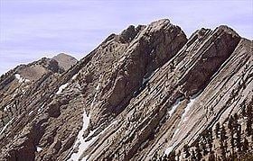
Currant Mountain is the highest mountain in the White Pine Range in White Pine County, Nevada, United States. It is the twenty-first-highest mountain in the state, and also ranks as the sixteenth-most topographically prominent peak in the state. Its summit consists of a series of three spires on a thin limestone ridge, with the southern spire being the highest at 11,518 feet (3,511 m). To the west are the Duckwater (Shoshone) tribal lands and the northern arm of large Railroad Valley. To the east is the northern part of White River Valley. The peak is located about 37 miles (60 km) southwest of the community of Ely near the Nye County border, within the Currant Mountain Wilderness of the Humboldt-Toiyabe National Forest.
Map of Currant Mountain, Nevada, USA
References
Currant Mountain Wikipedia(Text) CC BY-SA