
Country Area 70.59 km2 Mayor Marcelo Cabrera | Population 329,928 (2010) Founded Gil Ramirez Davalos | |
 | ||
Points of interest Colleges and Universities University of Cuenca, Politecnica Salesiana University, Universidad Catolica de Cuenca, University of Azuay, University of The Pacific | ||
Map of Cuenca, Ecuador
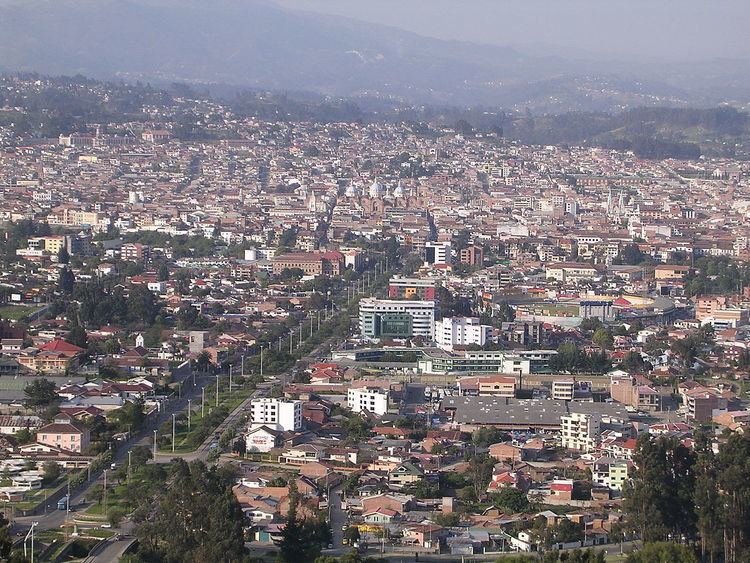
The city of Cuenca — in full, Santa Ana de los Cuatro Ríos de Cuenca — is the capital of the Azuay Province. It is widely regarded as the most European city in the country of Ecuador due to its 16th and 17th century era Spanish colonial architecture resembling cities and architecture throughout Spain. The city of Cuenca is located in the highlands of Ecuador at about 2,500 metres (8,200 feet) above sea level, with an urban population of approximately 400,000 rising to 700,000 inhabitants in the larger metropolitan area. The centre of the city is listed as a UNESCO World Heritage Trust site due to its many historical buildings.
Contents
- Map of Cuenca Ecuador
- To live in cuenca ecuador
- Townsplaces to visit only an hour away from cuenca ecuador
- First inhabitants
- Pre Columbian society
- Spanish settlement
- Population
- Economy
- Geography and location Economy
- Parishes
- Climate
- Universities
- Primary and secondary schools
- Main sights
- Landmarks
- Surroundings
- Festivities
- Bus station
- Airport
- Cuenca Public Transportation Statistics
- Twin towns Sister cities
- Best food in cuenca ecuador
- traditional foods of cuenca and quito ecuador lets eat
- Cuenca ecuador restaurant milanos 2 50 breakfast
- References
To live in cuenca ecuador
Townsplaces to visit only an hour away from cuenca ecuador
First inhabitants
According to studies and archeological discoveries, the origins of the first inhabitants go back to the year 8060 BC in the Cave of Chopsi. They were hunters, hunting everything the Páramo offered them, and nomads, following the animals and seasons. Their culture is represented by tools such as arrows and spears, which have been found throughout the Andean valley. The culture was most present about 5585 BC.
Later the early indigenous people used the stable climate, fertile soil and abundant water to develop agriculture. They grew potatoes, melloco, chocho, squash and quinoa. They also domesticated animals such as cuys (guinea pigs) and camelids: llamas and alpacas.
Their technology was also advanced. For example, they started creating ceramics. In fact, ceramics constitute the greatest number of artifacts which archeologists use to study their culture. The period from 5000 BCE to 2000 BCE is not represented well in the archeological record. Beginning around 2000 BCE, the people developed a more highly organized society, demonstrating delegated responsibilities, such as the managing of water and control of plagues. People were specialized as administrative and religious authorities (known as shamans). This occurred during the periods of Chaullabamba, Huayco, Pirincay, Monjas, Putushio, Huancarcucho and Jubones. From then until 500 AD began the periods of Tacalshapa III and the Cañari people, who were absorbed into the Incas in the 15th century.
Pre-Columbian society
Cuenca was originally a Cañari settlement called Guapondeleg. Archeologists believe Cuenca was founded around 500 AD. Guapondeleg translates into "land as big as heaven." Less than half a century before the conquistadors landed, the Incas, after a bitter struggle, conquered the Cañari and occupied Guapondeleg and the surrounding area. Though the Incas replaced the Cañari architecture with their own, they did not suppress the Cañari or their impressive achievements in astronomy and agriculture. As was customary for the Incas, they absorbed useful achievements into their culture. They renamed the city Tomebamba. The city became known as the second Cusco, a regional capital.
After the defeat of the Cañari, probably in the 1470s, the Inca emperor, Tupac Yupanqui, ordered the construction of a grand city to be called Pumapungo, "the door of the Puma". Its magnificence was said to have rivaled that of the Inca capital of Cuzco. Indians told stories to the Spanish chroniclers of golden temples and other such wonders, but by the time the Spaniards found the legendary city, all that remained were ruins. They wondered what happened to the fabled splendor and riches of the second Inca capital. After having been abandoned by the Cañari and then the Incas, Tomebamba was sparsely populated until the 1550s.
Tomebamba is considered a candidate for the mythical city of gold which the Spanish called El Dorado. The Spanish thought El Dorado was burned by the inhabitants after they heard of the Spanish conquests. Tomebamba's destruction by its inhabitants prior to the arrival of the Spanish suggests it may have been what the Spanish called El Dorado.
Spanish settlement
The Spanish settlement of Cuenca was founded on April 12, 1557 by the explorer Gil Ramírez Dávalos. Andrés Hurtado de Mendoza, then Viceroy of Peru had commissioned the founding and ordered the city named after his home town of Cuenca, Spain. It was founded decades after other major Spanish settlements in the region, such as Quito (1534), Guayaquil (1538), and Loja (1548). Cuenca's population and importance grew steadily during the colonial era. It reached the peak of its importance in the first years of Ecuador's independence; Cuenca achieved its independence on November 3, 1820. It became the capital of one of the three provinces that made up the nascent republic. The other two capitals were Guayaquil and Quito.
Population
As per the last INEC estimate for 2015, the population of the Cuenca canton was 580,000 inhabitants, of which 400,000 constitute the urban population (i.e., the population of the city proper). The economic development is based on industry and agricultural development.
Cuenca Metropolitan Area includes the cities of Azogues, Biblian and Deleg in the cañar province and the cities of Paute and Gualaceo in the Azuay province with a population of 730,000 inhabitants, however, Cuenca's influence in the cultural, economic and educational areas extends to all the remaining cities 50 miles (80 kilometres) around.
Economy
Cuenca is a city known for its textile making, along with furniture and other crafts like hats and shoes. They also export many flowers to places such as the United States and countries in Europe. The hats that they are well known for making are straw hats. The tourism industry is big as well in addition with the main university there, “La Universidad de Cuenca”. Cuenca has many cathedrals there that are a part of the sightseeing as well as other national parks. For the future, Ecuador has been working on electrolytic hydrogen for use of better resources that are environmental friendly. With Cuenca located in the sierras of mountains and much forest area nearby, mining and logging are industries there. Some of the common mined resources are kaolin, plaster, limestone, sand, specialized rocks, and carbon. Also, Cuenca is known for making tires for cars. They get a big supply of rubber from the forests. As far as farming, it has shrunken in the economy, but is still important part of the city. Beekeeping is actually a big part of it as far as the usual of livestock and growing crops. Some of the typical crops grown are wheat, barley, rye, oats and corn.
Geography and location Economy
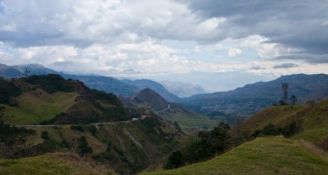
Cuenca, capital of the province of Azuay, is located in the sierra of the Andes in the Austro or southern region of Ecuador. It is approximately nine hours south of Quito and four hours east of Guayaquil. The city ranges from 2,350 to 2,550 metres (7,710 to 8,370 feet) above sea level.
The dominant features of the city's geography are also the source of its name in Spanish: the four rivers of Cuenca (meaning a basin made by a confluence of rivers). These rivers are the Tomebamba (named after the Inca culture), Yanuncay, Tarqui and Machangara, in order of importance. The first three of these rivers originate in the Páramo of Parque Nacional Cajas to the west of the city. These four rivers are part of the Amazon river watershed. Cuenca is surrounded by mountains on all sides, with passes to the west, south and east.
Parishes
Cuenca Canton contains the following parishes:
Climate
Cuenca features a subtropical highland climate (Cfb) under the Köppen climate classification. Like the rest of the Ecuadorian Andes, Cuenca enjoys a mild climate year-round. Days are generally warm and nights are cool enough that sweaters or jackets are usually desired. The average daily temperature is 14.7 °C (58.5 °F). There are two seasons: rainy and dry. The dry season, with some variation, falls between June and December. The rainy season, which is characterized by bright sunny mornings and afternoon showers, falls between January and May. The heaviest rains come in the invierno (wet season) of March, April and May.
Universities
The first university in the city was established in 1867 and is the Universidad de Cuenca. It is considered the third oldest university of the country, right after the Universidad Central del Ecuador (1836) and the Universidad Nacional de Loja (1859). Ever since, the city has been growing and more universities were created with new careers. This led to the declaration of Cuenca as the City of Universities by the National Assembly of Ecuador on January 4, 2011.
The city has the following Universities:
The first one is classified as an A category university the next two are B category and the last one is D category. This was stated by the Council for Evaluation, Validation and Assurance of the Quality in Superior Education of Ecuador (CEAACES)
Primary and secondary schools
International schools:
Main sights
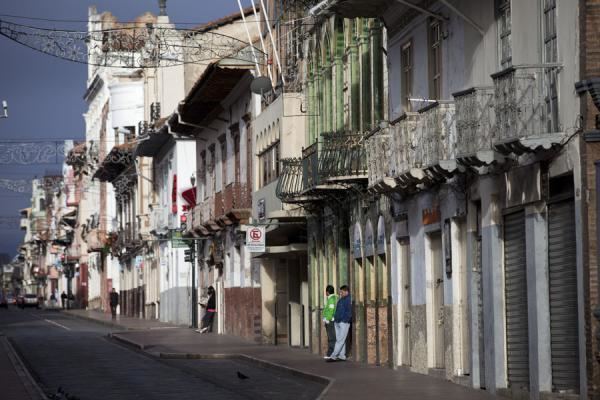
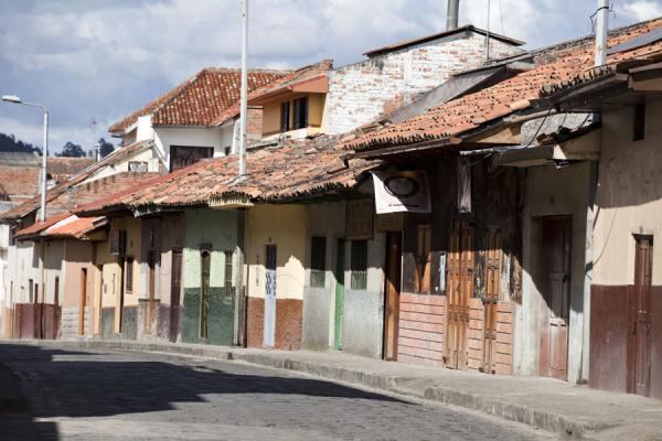
Most tourists visit the historic area, which is a UNESCO World Heritage Site, between the river Tomebamba and the street Gran Colombia to the north, General Torres to the west, and Hermano Miguel to the east. This area's compactness, grid-like layout, and numerous readily identifiable monuments make it easy to navigate. Outside this area the city can be confusing, as there are dozens of narrow colonial streets with similar buildings.
Major fiestas of Cuenca come at the time of the "Mass of Children" that is carried out the day of the Arrival of Kings (January 6 - Epiphany Day), or in the commemoration of the independence of the city (November 3), during which processions, cultural acts and dances are organized. The nearby Cañar plantation (in the county of the same name) features the biggest Inca ruins in Ecuador.
Landmarks
Surroundings
Festivities
One of the festivities celebrated in Cuenca and in other parts of Ecuador is "El Carnaval" This is celebrated three days prior to Ash Wednesday. Families get together to celebrate what started as a "pagan ritual". Now it is celebrated by wetting friends and random people with water balloons and spraying "Carioca" a non staining foam.
Bus station
Cuenca's inter-provincial bus station, called the Terminal Terrestre as it is in most cities, is well organized and clean. It is located on Avenida España in the northeastern corner of the city, a twenty-minute walk or a brief taxi ride from the historic center. Also, many City buses provide frequent service as indicated by the "Terminal Terrestre" placard on the windshield. A guide to using the City buses, maps of the routes and an online trip planner can be found at CuencaTransit.com
Buses arrive and depart throughout the day. Service is available to major cities, such as Guayaquil and Quito and also to nearby cities such as Loja, Riobamba, or Machala. The distance to Guayaquil is 243 km. and the bus takes nearly 4 hours on the highway Durán-Pto.Inca-Molleturo (I582W), a scenic ride through the Cajas National Park. Quito is 497 km from Cuenca and the trip takes around 10 hours on the Road Pan-American Highway (I35N). Many prefer to travel by bus at night. Those who choose to travel overnight should exercise caution due to reported bus hijacks which have resulted in armed robbery. [citation needed]
Airport
The airport, named Aeropuerto Mariscal Lamar (Mariscal Lamar International Airport), is due east of the Terminal Terrestre (bus station) on Avenida España. It's a 5-minute walk from the bus station. Four airlines currently serve Cuenca; AeroGal, LAN Ecuador, and TAME fly to Quito daily while Línea Aérea Cuencana (no longer operating as of November 2013) and TAME fly to Guayaquil. This is Ecuador's third busiest airport. Over 1,400,000 passengers a year pass through its gates.
Cuenca Public Transportation Statistics
According to the Moovit Public Transport Index, Cuenca's bus system compares extremely favourably with other cities in Latin America. The average amount of time people spend commuting with public transit in Cuenca, for example to and from work, on a weekday is 51 minutes, with only 7% of public transit riders riding for more than 2 hours every day. The average amount of time people wait at a bus stop or bus station for public transit is 11 minutes, while a mere 9% of riders wait for over 20 minutes on average every day. The average distance people usually ride in a single trip with public transit is 3.8 km, while 0% travel for over 12 km in a single direction. In 2017, the flat-rate bus fare is 25 US cents, 12 cents for children and seniors.
Twin towns – Sister cities
Cuenca is twinned with: