
Elevation 385 m | ||
 | ||
Similar Ysgafell Wen, Allt‑fawr, Roman Bridge railway st, Manod Mawr, Moel Penamnen | ||
Crimea pass
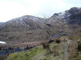
The Crimea Pass (Welsh: Bwlch y Gorddinan) is a mountain pass in north Wales, on the A470 road between Blaenau Ffestiniog and Dolwyddelan connecting the counties of Gwynedd and Conwy.
Contents
- Crimea pass
- Map of Bwlch Y Gorddinan Dolwyddelan UK
- Crimea pass climb descent into blaenau ffestiniog
- References
Map of Bwlch Y Gorddinan, Dolwyddelan, UK
At its highest point, it is 385 metres (1,263 ft) above sea level, and is sometimes closed in winter because of snow. At one time there was an inn at the summit of the pass, popularly known as "the Crimea".
It takes its name from the Crimean War which was being fought about the time the road was opened, in 1854. By repute construction of the stone walls in the area was carried out by Russian prisoners of war captured at the Battles of Inkerman and Balaclava.
In 2008 major highway improvement work on the A470 through the Pass was completed, this including the downhill section to the north of the pass, and southwards down to Blaenau Ffestiniog.