
Prominence 2,582 ft (787 m) Population 1,519 (2013) | Isolation 4.65 mi (7.48 km) Elevation 2,716 m | |
 | ||
Topo map USGS 7.5' topographic mapGothic, Colorado Weather -19°C, Wind N at 8 km/h, 81% Humidity Points of interest Kebler Pass, Crested Butte Nordic, Crested Butte Mountain, Rainbow Park, Crested Butte Town Park | ||
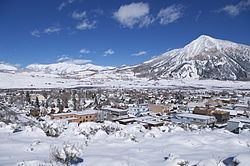
Crested Butte is a prominent mountain summit in the West Elk Mountains range of the Rocky Mountains of North America. The 12,168-foot (3,709 m) peak is located in Gunnison National Forest, 2.1 miles (3.4 km) northeast by east (bearing 59°) of the Town of Crested Butte in Gunnison County, Colorado, United States. Ski lifts and runs of the Crested Butte Mountain Resort occupy the north side of the mountain.
Contents
Map of Crested Butte, CO 81224, USA
ClimateEdit
The Köppen Climate Classification subtype for Crested Butte is "Dfc" which is continental subarctic. This climate type is dominated by the winter season with a long, bitterly cold period of minimal daylight hours, heavy snowfall and low humidity. The annual snowfall average is 198.4 inches (504 cm) with January recording the highest average snowfall at 40 inches (100 cm). July is the warmest month with an average temperature of 57.2 °F (14.0 °C) while January is the coldest month with an average temperature of 11.8 °F (−11.2 °C). The average temperature for the year is 34.7 °F (1.5 °C).