
Island group British Isles | ||
 | ||
Similar | ||
Cramond island
Cramond Island (Scottish Gaelic Eilean Chathair Amain) is one of several islands in the Firth of Forth in eastern Scotland, near Edinburgh. It lies off the foreshore at Cramond. It is 1⁄3 mile (0.54 km) long and covers 19.03 acres (7.70 ha). The island is part of the Dalmeny Estate, owned by the Rosebery Estates Partnership, and is let to Cramond Boat Club.
Contents
- Cramond island
- Map of Cramond Island United Kingdom
- GeographyEdit
- HistoryEdit
- World War IIEdit
- References
Map of Cramond Island, United Kingdom
GeographyEdit
Cramond Island is a tidal island about one mile (1.6 km) out to sea, which is connected to the mainland at low tide across the Drum Sands. A paved path, exposed at low water, allows easy access. This causeway runs at the foot of a row of concrete pylons on one side of the causeway, which were constructed as a submarine defence boom during the Second World War and are one of the most striking sights in the area. At high tide the path is covered by several feet of seawater which cuts the island off from the mainland. It is safe to walk along the raised causeway to the island at low tide, but only if visitors ensure that they leave enough time to return to the mainland before the water rises. The speed at which the tide comes in can easily trap the unwary. A large signpost (located at the start of the causeway) warns visitors of the danger. If this warning is ignored, there can be serious accidents or people may be stranded on the island until the next low tide. In 2011, a Daniel Defoe of Livingston, West Lothian and an unidentified female found themselves trapped on the island due to miscalculating the times of the tide. This story gained the attention due to the ironic parallels with Robinson Crusoe; a novel written by the 17th century writer Daniel Defoe. Coastguards recommend that the crossing is only attempted during the two hours either side of low water. The island is in the estuary of the River Almond whose mouth is near the landward end of the crossing. It is a popular recreation area.
Cramond Island is one of 43 tidal islands that can be walked to from the mainland of Great Britain and one of 17 that can be walked to from the Scottish mainland.
HistoryEdit
There is evidence to suggest that the island may have had special significance to the prehistoric peoples who lived along the coast of the Firth of Forth, as at least one stone burial cist was found.
As nearby Cramond was a Roman outpost, it is likely that it may have been used by them. The Roman presence in Scotland was not particularly strong, but Cramond is one of the most archaeologically rich sites, along with Trimontium near Melrose.
Throughout most of its history, Cramond Island was used for farming, especially sheep-farming, and perhaps served as a fishing outpost as well. The island was once famous for its oyster beds, but these were destroyed due to overfishing. In the north west corner of the island there are remains of a jetty built with local stone which could be medieval in origin, while towards the centre of the island, half-hidden by a small wood there is the ruin of a stone-built farmstead. It appears on an Ordnance Survey map of 1853, but may be considerably older. It was occupied until the 1930s and sheep were still kept on the island as late as the 1960s.
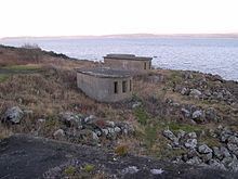
World War IIEdit
At the outbreak of World War II, Cramond Island, along with other islands in the Forth, was fortified to protect the coasts in the event of enemy warships entering the channel. A number of these buildings remain and can be explored. After crossing the causeway, the first structures are the emplacements for a 75 mm gun and its associated searchlight. More buildings are in the north east corner of the island, which include a variety of stores, shelters and gun emplacements, as well as two engine rooms that once contained all the equipment necessary to supply power to the military installations on the island.
Further along the northern coast, low concrete stumps protrude from the undergrowth, all that remain of the barracks that housed the garrison on the island.
On the western side is a small brick building of unknown purpose. Nearby, perched precariously on the rocky shore is the ruin of a small square building which was used as an ammunition store during the war, though its stone construction suggests it is much older than either World War, possibly contemporary with the farmstead in the middle of the island.