
Airport type Public Elevation AMSL 6,193 ft / 1,888 m 5,600 1,707 Code CIG | 7/25 5,600 1,707 Asphalt Elevation 1,888 m | |
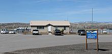 | ||
Craig–Moffat Airport (IATA: CIG, ICAO: KCAG, FAA LID: CAG) (Craig–Moffat County Airport) is a public airport two miles southeast of Craig, in Moffat County, Colorado.
Contents
Most U.S. airports use the same three-letter location identifier for the FAA and IATA, but Craig–Moffat Airport is CAG to the FAA and CIG to the IATA (which assigned CAG to Cagliari Elmas Airport in Italy).
Facilities
Craig–Moffat Airport covers 277 acres (112 ha); its one runway (7/25) is 5,600 x 100 ft. (1,707 x 30 m) asphalt.
In the year ending August 29, 2005 the airport had 2,525 aircraft operations, all general aviation.
Past airline service
In the mid 1970s the airport was served by Rocky Mountain Airways with de Havilland Canada DHC-6 Twin Otters to Denver.
Incident
In 2001 a McDonnell Douglas MD-80 operated by Trans World Airlines mistakenly landed at the airport during a snow shower. Flight 641 from St. Louis was scheduled to land at nearby Yampa Valley Airport (HDN) in Hayden, CO. There were no injuries to the 122 people on board, but the jet got stuck in the mud as it tried to follow the taxiway.