
Local time Tuesday 8:41 PM | ||
 | ||
Weather 9°C, Wind S at 21 km/h, 91% Humidity | ||
Crackington haven cornwall lifestyle business for sale
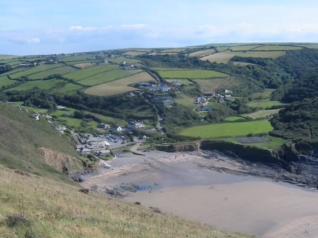
Crackington Haven (Cornish: Porthkragen, meaning "cove of the little crag") is a coastal village in Cornwall, England, United Kingdom. It is in the civil parish of St Gennys (where the 2011 census population was included) at grid reference SX140972 at the head of a cove on the Atlantic coast. The village is seven miles (11 km) south-southwest of Bude and four miles (7 km) north-northeast of Boscastle.
Contents
- Crackington haven cornwall lifestyle business for sale
- Map of Crackington Haven Bude UK
- Geography
- History
- References
Map of Crackington Haven, Bude, UK
Middle Crackington and Higher Crackington are associated settlements. They are situated on the hill southeast of Crackington Haven, half-a-mile and one mile distant respectively.
Geography
Crackington Haven is popular with tourists, walkers and geology students. The surrounding cliffs are well known for their visible folded sedimentary rock formations. The village gives its name to the Crackington formation, a sequence of Carboniferous sandstones and grey shales.
The village has a small shop, two tea rooms and a pub called the Coombe Barton Inn in a building which was originally the house of the manager of a local slate quarry.
Crackington Haven has a stony foreshore but a sandy beach is revealed at low water. There are toilet facilities near the beach and lifeguard cover in the summer.
Immediately north of the beach is Pencarrow Point and a few hundred yards south is Cambeak headland (between Tremoutha Haven and Cam Strand); the clifftop here is 328 ft. Cambeak is derived from Old Cornish and means "crooked point". One mile south of Crackington Haven, High Cliff rises to 735 feet (224 m) with a sheer drop to the rocky foreshore. It is Cornwall's highest cliff and is also classified as southern Britain's highest sheer-drop cliff (Great Hangman in Devon has a cliff face of 820 feet (250 m).
Crackington Haven lies within the Cornwall Area of Outstanding Natural Beauty (AONB). Almost a third of Cornwall has AONB designation, with the same status and protection as a National Park.
History
The manor of Crackington was recorded in the Domesday Book (1086) when it was one of several manors held by Berner from Robert, Count of Mortain. There was half a hide of land and land for 3 ploughs. There were 1 plough, 2 serfs, 6 smallholders, 4 acres of underwood, 20 acres of pasture, 4 cattle, 3 pigs and 25 sheep. The value of the manor was 10 shillings though it had formerly been worth £1 sterling.
Until the nineteenth century, Crackington Haven was a small port similar to many others on the north coast of Cornwall. Limestone and coal were imported and slate and other local produce were exported. After the railways reached the district in 1893 the village could be reached more easily (from the North Cornwall Railway station at Otterham) so holidaymaking became more common.
Crackington Haven was badly affected in 2004 by the flood that damaged several other villages, including Boscastle in the flood of 2004. The road bridge across the stream, several homes and pub were damaged by floodwater at this time.