
Area 6.85 km² Local time Wednesday 12:57 AM | Time zone BST (UTC+6) Elevation 3 m Number of airports 1 | |
 | ||
Weather 25°C, Wind S at 0 km/h, 89% Humidity University Cox’s Bazar Medical College Neighborhoods Kolatoli, Chainda, Badar Mokam, Mohori Para, Konarpara, Uttaran Somobay Residential Area Points of interest St Martin's Island, Laboni Beach, Sea Inn Beach Point, Kolatoli Beach, Shaheed Minar | ||
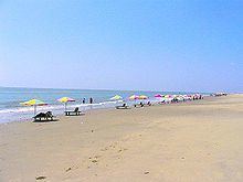
Cox's Bazar (Bengali: কক্সবাজার, Koksbajar, Koksbazar or Kokshbajar) is a town, a fishing port and district headquarters in Bangladesh. The beach in Cox's Bazar is an unbroken 120 km (75 mi) sandy sea beach with a gentle slope, one of the world's longest. It is located 150 km (93 mi) south of the industrial port Chittagong. Cox's Bazar is also known by the name Panowa, whose literal translation means "yellow flower." Its other old name was "Palongkee".
Contents
- Map of Coxs Bazar Bangladesh
- Town
- History
- Geography and climate
- Important Educational Institutions
- Economy and development
- Tourist attractions near the town
- References
Map of Cox's Bazar, Bangladesh
The modern Cox's Bazar derives its name from Captain Hiram Cox (died 1799), an officer of the British East India Company. Cox was appointed Superintendent of Palongkee outpost after Warren Hastings became Governor of Bengal. Captain Cox was specially mobilised to deal with a century-long conflict between Arakan refugees and local Rakhains. He embarked upon the task of rehabilitating refugees in the area and made significant progress. Captain Cox died in 1799 before he could finish his work. To commemorate his role in rehabilitation work, a market was established and named Cox's Bazar ("Cox's Market") after him.
Today, Cox's Bazar is one of the most-visited tourist destinations in Bangladesh, though it is not a major international tourist destination. In 2013, the Bangladesh Government formed the Tourist Police unit to better protect local and foreign tourists, as well as to look after the nature and wildlife in the tourist spots of Cox's Bazar.
Town
Cox's Bazar (Town), Cox's Bazar municipality, was constituted in 1869, eventually becoming a B-grade municipality in 1989. Located along the Bay of Bengal in South Eastern Bangladesh, Cox's Bazar Town is a large port and health resort. But it is famous mostly for its long natural sandy beach. The municipality covers an area of 6.85 km2 (2.64 sq mi) with 27 mahallas and 9 wards and has a population of 51,918. Cox's Bazar is connected by road and air with Chittagong.
History
The greater Chittagong area, including Cox's Bazar, was under the rule of Arakan kings from the early 9th century until its conquest by the Mughals in 1666 AD. When the Mughal Prince Shah Shuja was passing through the hilly terrain of the present-day Cox's Bazar on his way to Arakan, he was attracted to its scenic and captivating beauty. He commanded his forces to camp there. His retinue of one thousand palanquins stopped there for some time. A place named Dulahazara, meaning "one thousand palanquins," still exists in the area. After the Mughals, the place came under the control of the Tipras and the Arakanese, followed by the Portuguese and then the British.
The name Cox's Bazar/Bazaar originated from the name of a British East India Company officer, Captain Hiram Cox, who was appointed as the Superintendent of Palonki (today's Cox's Bazar) outpost. He succeeded Warren Hastings, who became the Governor of Bengal following the British East India Company Act in 1773. Cox was mobilised to deal with a century-long conflict between Arakan refugees and local Rakhine people at Palonki. The Captain had rehabilitated many refugees in the area, but had died (in 1799) before he could finish his work. To commemorate that, a market was established and named after him, called Cox's Bazar (market of Cox). Cox's Bazar then was first established in 1854 and became a municipality in 1869.
After the Sepoy Mutiny (Indian Rebellion of 1857) in 1857, the British East India Company was highly criticised and questioned on humanitarian grounds, specially for its opium trade monopoly over the Indian Sub-Continent. However, after its dissolution on 1 January 1874, all of the company's assets including its Armed Forces were acquired by the British Crown. After this historic take over, Cox's Bazar was declared a district of the Bengal Province under the British Crown.
After the end of British rule in 1947, Cox's Bazar became part of East Pakistan. Captain Advocate Fazlul Karim, the first chairman (after independence from the British) of Cox's Bazar Municipality, established the Tamarisk Forest along the beach. He wanted to attract tourists as well as to protect the beach from tsunami. He donated much of his father-in-law's and his own lands as sites for constructing a Public Library and a Town Hall. He was inspired to build Cox's Bazar as a tourist spot after seeing beaches of Bombay and Karachi, and was a resort pioneer in developing Cox's Bazar as a destination. He founded a Maternity Hospital, the Stadium and the drainage system by procuring grants from the Ford Foundation and Rockefeller Foundation through correspondence. T. H. Matthews, the principal of the Dacca Engineering College (1949~1954), was a friend who had helped him in these fundraising efforts. Engineer Chandi Charan Das was the government civil engineer who had worked on all these projects. In 1959 the municipality was turned into a town committee.
In 1961 the Geological Survey of Pakistan initiated investigation of radioactive minerals like monazite around the Cox's Bazar sea-beach area.
In 1971, Cox's Bazar wharf was used as a naval port by the Pakistan Navy's gunboats. This and the nearby airstrip of the Pakistan Air Force were the scene of intense shelling by the Indian Navy during the Bangladesh Liberation War. During the war, Pakistani soldiers killed many people in the town, including eminent lawyer Jnanendralal Chowdhury. The killing of two freedom fighters named Farhad and Subhash at Badar Mokam area is also recorded in history.
After the independence of Bangladesh, Cox's Bazar started to get administrative attention. In 1972 the town committee of Cox's Bazar was turned into a municipality. In 1975, The Government of Bangladesh established a pilot plant at Kalatali. Later, in 1984 Cox's Bazar subdivision was promoted to a district, and five years later (in 1989) the Cox's Bazar municipality was elevated to B-grade. In 1994 (jobs) the Marine Fisheries and Technology Station (MFTS) was established at Cox's Bazar. MFTS is a research station of Bangladesh Fisheries Research Institute (BFRI) headquartered in Mymensingh. The station covers a land area of four hectares and contains five laboratories. In April 2007 Bangladesh got connected to the submarine cable network as a member of the SEA-ME-WE-4 Consortium, as Cox's Bazar was selected as the landing station of the submarine cable. In September 2012 the municipality was the site of the Cox's Bazar and Ramu riots, where local Muslims attacked the Buddhist community over an alleged Quran desecration posted to Facebook.
Geography and climate
Cox's Bazar town with an area of 6.85 km2 (2.64 sq mi), is located at 21°35′0″N 92°01′0″E and bounded by Bakkhali River on the north and East, Bay of Bengal in the West, and Jhilwanj Union in the south.
The climate of Bangladesh is mostly determined by its location in the tropical monsoon region: high temperature, heavy rainfall, generally excessive humidity, and distinct seasonal variations. The climate of Cox's bazar is mostly similar to the rest of the country. It is further characterised by the location in the coastal area. The annual average temperature in Cox's Bazar remains at about a maximum of 34.8 °C (94.6 °F) and a minimum of 16.1 °C (61.0 °F). The average amount of rainfall remains at 3,524 mm (138.7 in).
Important Educational Institutions
1962: Cox's Bazar Govt. College is the earliest Secondary and bachelor's degree offering college founded in Cox's Bazar.
1985: Cox's Bazar Law College is the first profession based college founded in this district.
1991: Cox's Bazar Govt. Women's College is the first Secondary and bachelor's degree offering college in this district solely for women.
2008: Cox's Bazar Medical College is the first medical college in this district.
Other Colleges in this area: Cox's Bazar City College, Ramu Degree College, Ukhiya Degree College, Teknaf Degree College, Moheskhali degree college
High Schools: Cox's Bazar Govt. High School, Cox's Bazar Govt. Girls High School, Cox's Bazar Model High School,Kishalaya Model High School, Chokoria, Korak Bidda-pith, Chokoria, Chokoria Govt. High School, Palong Model High School,Shilkhali High School,Pekua.
Economy and development
As one of the most beautiful and famous tourist spots in Bangladesh, the major source of economy in Cox's Bazar is tourism. Millions of foreigners and Bangladeshi natives visit this city every year. As a result, a large number of hotels, guest houses and motels have been built in the city and coastal region. Many people are involved in hospitality and customer service orientated businesses. The number of high-end hotels in the city was about 2 or 3 about 5 years ago, but today there are dozens and counting. A few international hotel chains now operate in the city, but others are planning to build hotels here.
People are also involved in fishing and collecting seafood and sea products for their livelihood. Oysters, snails, pearls and their ornaments are very popular with tourists. Some people are involved in the transportation business for tourists. Cox's Bazar is one of the few major spots for aquaculture in Bangladesh. Along with Khulna, it is considered a major source of revenue from foreign exchanges. Beside a mix of small-scale agriculture, marine and inland fishing and salt production are other industrial sources that play important roles in the national economy.
Tourist attractions near the town
The beach is the main attraction of the town. Larger hotels provide exclusive beachside area with accessories for the hotel guests. Visitors in other hotels visit the Laboni beach which is the area of the beach closest to the town. Other than the beach there are several places of interest near the town which can easily be visited from town centre.