
Country Bangladesh Time zone BST (UTC+6) Area 33,771 km² | Capital Chittagong ISO 3166 code BD-B Team Comilla Victorians | |
 | ||
Points of interest St. Martin's Island, Chittagong Zoo Colleges and Universities University of Chittagong, Comilla Victoria Governm, Noakhali Government College, Chittagong University of Engine, International Islamic University Destinations Chittagong, Cox's Bazar, Kaptai Upazila, Comilla, Rangamati Similar Chittagong, Chittagong District, Cox's Bazar | ||
Bangladesh chittagong division
Contents
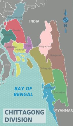
Map of Chittagong Division, Bangladesh
Chittagong Division (Bengali: চট্টগ্রাম বিভাগ) is geographically the largest of the eight administrative divisions of Bangladesh. It covers the south-easternmost areas of the country, with a total area of 33,771.18 km2 (13,039.13 sq mi) and a population at the 2011 census of 28,423,019.
Chittagong Division is home to Cox's Bazaar, one of the world's longest natural beaches; as well as St. Martin's Island, Bangladesh's sole coral reef.
Administration
Chittagong division is subdivided into eleven districts (zilas) and thence into 99 sub-districts (upazilas). The first six districts listed below comprise the north-western portion (37.6%) of the division, while the remaining five comprise the south-eastern portion (62.4%), the two portions being separated by the lower (or Bangladeshi) stretch of the Feni River; the upland districts of Khagrachhari, Rangamati and Bandarban together comprise that area previously known as the Chittagong Hill Tracts. Before 1995, the six districts of Sylhet Division were also a part of Chittagong Division.