Google Street View was first introduced in the United States on May 25, 2007, and until November 26, 2008, featured camera icon markers, each representing at least one major city or area (such as a park), and usually the other nearby cities, towns, suburbs, and parks. Many areas that had coverage were represented by icons.
On May 25, 2007, Street View was announced.
On May 30, 2007, at the Where 2.0 Conference, Immersive Media was identified as the contractor that captured the imagery for four of the five cities initially mapped by Street View, using its patented dodecahedral camera array on a moving car. Immersive Media continued to do image capture for Street View until Google developed its own capability to do so. Since July 2007, Google has used imagery that belongs exclusively to Google.
On April 16, 2008, Street View was fully integrated into Google Earth 4.3.
On May 12, 2008, Google announced that it was testing face-blurring technology on its photos of the busy streets of Manhattan. The technology uses a computer algorithm to search Google's image database for faces and blurs them, according to John Hanke, director of Google Earth and Google Maps.
On June 10, 2008, two other features included in the update were an effective mask of the "Google Car" and the application of face-blurring technology on all photos, which effectively lowered the resolution across all photos, even the formerly impressive high resolution images of San Francisco. Also, many nearby metro areas were included, but they did not receive their own camera icons.
On July 2, 2008, Google Street View was introduced in France and Italy, providing the first service outside the United States and the debut of Google's new 4th Generation Cameras. On this day, 19 camera icons were added, mostly showing small towns and areas along the Tour de France route and part of north western Italy
On August 4, 2008, 28 icons of major metropolitan areas of both Australia and Japan were added to Google Street View. Included in the update were approximately 40 new U.S. hub cities.
On November 26, 2008, the Street View button and all the camera icons were deleted. Instead of clicking the "Street View" button, this is now accessed using the "pegman" button in the left hand corner. When the "pegman" icon is dragged over the map blue polylines appear where Street View is available and a small window will show the current Street View. If this is dropped on the map the Street View opens and takes over the whole map window.
On December 1, 2008, New Zealand was added to Google Street View. Faces were blurred upon recommendation by the New Zealand Privacy Commission, but vehicle registration plates were not obscured.
On April 9, 2009, Street View became available with a full-screen option.
On June 5, 2009, Smart Navigation was introduced which allows users to navigate around the panoramas by double-clicking with their cursor on any place or object they want to see.
In mid-June 2010, Google added blue dots to its maps that display user-submitted images in all locations around the world, including land areas where Street View is not available and bodies of water. These images can be pulled up on the screen in the same manner as a Street View image with the pegman by dragging it onto the blue dot.
On October 30, 2012, Google announced that users can contribute to Street View by creating a panorama-like image from the Galaxy Nexus smartphone to share on Google Maps.
On February 14, 2013, Wii Street U was released for the Wii U.
On June 27, 2013, Google announced that users can contribute to Street View by creating a panorama-like image from the Galaxy non-Nexus smartphone to share on Google Maps.
On April 23, 2014, a new historical Street View option was introduced to new Google Maps. The date of panoramas can be selected from the timeline.
* Limited coverage.
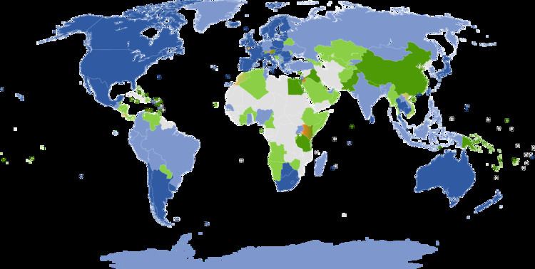
Below is a table showing the countries available on Street View and the year they were first added. Plain text indicates that a country has only views of certain businesses and/or tourist attractions.
Bold with an asterisk (*) indicates countries with public street view available
Below is list of the countries that do not currently have official coverage where Street View vehicles are currently driving, where Street View is officially planned, or have reported by media to be driving.
Public streets in Austria, Guernsey and India (Bangalore), as well more places in Germany were filmed but at this time the images are not online due to some privacy concerns.