
Country United States Time zone Central (CST) (UTC-6) Elevation 174 m Population 604 (2013) | Incorporated December 13, 1819 Area code(s) 256 Zip code 35618 Local time Tuesday 8:38 AM | |
 | ||
Weather 16°C, Wind S at 27 km/h, 86% Humidity | ||
Help courtland alabama traffic speeding ticket lawyer best courtland al traffic attorney
Courtland is a town in Lawrence County, Alabama, United States, and is included in the Decatur Metropolitan Area, as well as the Huntsville-Decatur Combined Statistical Area. The population was 609 at the 2010 census, down from 769 in 2000.
Contents
- Help courtland alabama traffic speeding ticket lawyer best courtland al traffic attorney
- Map of Courtland AL USA
- Geography
- Demographics
- Early History
- One of the Souths First Railroads 1832
- The Red Rovers
- Courtlands Early Architecture
- World War II
- Notable people
- References
Map of Courtland, AL, USA
Geography
Courtland is located at 34°40′6″N 87°18′39″W (34.668457, -87.310821).
According to the U.S. Census Bureau, the town has a total area of 2.3 square miles (6.0 km2), of which 2.3 square miles (6.0 km2) is land and 0.43% is water.
Demographics
From 1880 until 1910, Courtland was the largest town in Lawrence County, losing the distinction in 1920 to the county seat of Moulton, which has held it to date (as of 2010).
As of the census of 2000, there were 769 people, 316 households, and 210 families residing in the town. The population density was 331.2 people per square mile (128.0/km2). There were 363 housing units at an average density of 156.4 per square mile (60.4/km2). The racial makeup of the town was 54.23% White, 40.44% Black or African American, 2.08% Native American, 0.26% Asian, 0.13% Pacific Islander, and 2.86% from two or more races. 0.91% of the population were Hispanic or Latino of any race.
There were 316 households out of which 32.9% had children under the age of 18 living with them, 44.0% were married couples living together, 20.3% had a female householder with no husband present, and 33.5% were non-families. 30.7% of all households were made up of individuals and 14.2% had someone living alone who was 65 years of age or older. The average household size was 2.43 and the average family size was 3.06.
In the town, the population was spread out with 27.8% under the age of 18, 8.7% from 18 to 24, 26.9% from 25 to 44, 23.0% from 45 to 64, and 13.5% who were 65 years of age or older. The median age was 36 years. For every 100 females there were 85.7 males. For every 100 females age 18 and over, there were 77.3 males.
The median income for a household in the town was $27,500, and the median income for a family was $36,000. Males had a median income of $31,250 versus $17,188 for females. The per capita income for the town was $14,456. About 18.1% of families and 20.2% of the population were below the poverty line, including 22.7% of those under age 18 and 32.9% of those age 65 or over.
Early History
A small creek named Big Nance Creek runs through the town. The creek was named for a Cherokee Indian chief who lived in the area upon arrival of the first European settlers. The current town is reportedly located on the site of the Native American village.
Situated in the fertile Tennessee River Valley of North Alabama, Courtland was incorporated on December 13, 1819 by the Alabama territorial legislature. The town's early settlers were wealthy planters mostly from Virginia, Tennessee, the Carolinas and Georgia.
The early roads Gaines Trace and Byler Road went through town and connected to other places.
The town was named for having a federal courthouse and land office in the early 19th century.
One of the South's First Railroads - 1832
Seeking a means to ship cotton and other goods around the treacherous Muscle Shoals of the Tennessee River, area planters and merchants met at Courtland in 1831 to consider a rail line. On January 13, 1832, the 50 mile long Tuscumbia, Courtland and Decatur Railroad was chartered. Early trains were usually horse-drawn, although an English-made steam locomotive was acquired in 1834. Absorbed by the Memphis & Charleston line after 1850, the railway was largely destroyed during the Civil War. The rebuilt railroad became part of the southern system in 1898.
The Red Rovers
A volunteer military company was organized at Courtland in 1835 to aid Texas in its struggle for independence. Commanded by Dr. Jack Shackelford, a local physician, the company derived its name from the color of their home spun uniforms made by citizens of Courtland. The dye used was reportedly derived from the rich red clay abundant in the area. The Red Rovers were first assigned to a regiment that was cut off and captured by the Mexican Army at Coleta, Texas, on March 20, 1836. They surrendered on the promise of return to the U. S. On March 27, the company and others, 365 men total, were massacred at Goliad, Texas, by order of Gen. Santa Anna. Dr. Shackelford was spared and seven other Rovers were spared or escaped. Dr. Shackleford later escaped and returned to Courtland. The Goliad incident, plus the Alamo, rallied U. S. support and guaranteed freedom for Texas.
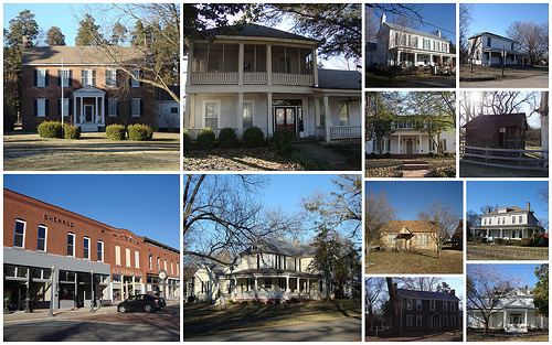
Courtland's Early Architecture
Structures within the Courtland historic district represent over 150 years of changing tastes in building design. Several of Courtland’s earliest buildings survive to this day. The Federal-style architecture of the oldest houses suggest the community’s strong original links with Virginia and other states of the upper South. Typical early residences of frame and brick feature a gable roof with tall chimneys at each end. Sometimes weatherboarding conceals log walls underneath. Many buildings dating from the 1850s through the 1930s reflect Italianate, Victorian and neoclassical architectural influences. There are also early 20th century “bungalows”, some built of native sandstone. Courtland still counts about twenty buildings predating the Civil War (1861). During the early 19th century, an assortment of wooden, brick and log business structures surrounded the town square. Most of the old buildings on the square today (north and east sides) date from the late 19th century and early 20th century. The fronts of some of them feature characteristic Victorian detailing. At the northeast corner of the square are four 19th-century stone mounting blocks placed for the convenience of horseback riders. The blocks were also supposedly used for selling slaves during the slave period. The tall red cedars seen throughout Courtland and along the streets radiating from the square have been a feature of the landscape since early days.
The John McMahon House, a Federal style home built around 1830, is listed on the National Register of Historic Places. Rocky Hill Castle was an architecturally renowned plantation on the outskirts of Courtland, it was demolished in 1961.
World War II
Courtland was home to the Courtland Army Airfield (Courtland AAF) in 1944 and 1945. It was dismantled immediately after WWII and given the city of Courtland to use as an airport. Today, it is Courtland Airport.