
Length 55.63 km | ||
 | ||
Counties | ||
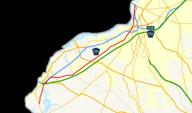
County Route 551, abbreviated CR 551, is a county highway in the U.S. state of New Jersey. The highway extends 34.57 miles (55.64 km) from Pennsville-Salem Road (Route 49) in Pennsville Township to Penn Street (Interstate 676 / U.S. Route 30) in Camden.
Contents
Map of County Rd 551, New Jersey, USA
Route description
CR 551 begins at an intersection with Route 49 in Pennsville Township, Salem County, heading north on two-lane undivided Hook Road. The road runs through a mix of farms and woods with some homes. The route passes through some marshland adjacent to the Salem River before entering residential areas. CR 551 crosses into Carneys Point Township and comes to an interchange with I-295 at the point where the New Jersey Turnpike and US 40 split from I-295. Here, CR 551 briefly merges onto I-295 before exiting the freeway at Route 140, at which point the route heads east for a brief concurrency with Route 140 in commercial areas. CR 551 splits from Route 140 by heading northeast on two-lane undivided Auburn Road, running through forested areas a short distance to the east of I-295, intersecting CR 618. The route turns east away from I-295 and intersects CR 629 as it passes to the north of a lake before coming to a junction with Route 48. Following this intersection, the road heads into a mix of farmland and woodland with a few homes, entering Oldmans Township at the CR 641 junction. The road comes to intersections with CR 643 and CR 644 before crossing CR 602 farther east. Upon intersecting CR 646, CR 551 turns northeast onto Hook Road and passes homes.
Upon crossing the marshy Oldmans Creek, CR 551 enters Woolwich Township in Gloucester County and becomes Auburn Avenue as it passes residential subdivisions before crossing CR 602 and heading into agricultural areas. The road enters areas of residential development again as it intersects CR 620 and CR 662. After crossing a Southern Railroad of New Jersey line, the route continues into Swedesboro and is lined with homes as it meets CR 671 before coming to a junction with CR 605 and CR 694. At this intersection, CR 551 turns onto Kings Highway and passes through the residential and commercial downtown of Swedesboro, reaching the junction with the western terminus of CR 538. The route crosses the Racoon Creek back into Woolwich Township and intersects CR 653 before passing a mix of farms and development as it comes to US 322/CR 536. CR 551 continues through more agricultural areas as it has junctions with CR 672 and CR 684. Continuing into East Greenwich Township, the route heads into areas of residential subdivisions as it crosses CR 607 and CR 664. After passing through some woods, the road heads into the residential community of Mickleton and intersects CR 673. In the community of Clarksboro, CR 551 reaches junctions with CR 667 and CR 707. The route crosses the Conrail Shared Assets Operations Salem Secondary before passing more homes in the community of Mount Royal, where there is an intersection with CR 678. CR 551 crosses the Mantua Creek into West Deptford Township and heads east between oil tanks to the north and residential areas to the south as it intersects CR 648, CR 643, and CR 656. The road continues near more homes and tank farms before crossing CR 660, where the setting becomes mainly residential. CR 551 enters Woodbury and becomes Salem Avenue as it enters commercial areas, crossing the Conrail Shared Assets Operations Penns Grove Secondary before reaching an intersection with Route 45.
Here, CR 551 forms a concurrency with four-lane Route 45 and heads north-northeast on Broad Street through the downtown of Woodbury. The road intersects CR 663 and continues through the downtown. Route 45 and CR 551 cross the Woodbury Creek out of the downtown area and intersect CR 644 near Underwood-Memorial Hospital. From here, the route continues past a mix of residences and businesses as a two-lane undivided road. CR 551 splits from Route 45 by heading east on Park Avenue, crossing the Conrail Shared Assets Operations Vineland Secondary before turning north on Broadway, entering Deptford Township. The road runs through commercial areas and intersects the northern terminus of CR 553. Farther north, CR 551 reaches a partial interchange with access to and from the northbound direction of I-295; southbound access is provided by Route 45 a short distance to the west. In the area of this interchange, the route is briefly a divided highway. Past I-295, the route continues into Westville and passes through more urban areas of homes and businesses as a two-lane undivided road. CR 551 passes through the commercial downtown of Westville before joining Route 47, running northeast through commercial areas as a four-lane undivided road.
After crossing the Big Timber Creek into Brooklawn, Camden County, the road comes to a traffic circle with US 130 and CR 753, where Route 47 ends and CR 551 turns west to follow US 130, passing under the Vineland Secondary. At another traffic circle, CR 551 splits from US 130 and heads northeast onto New Broadway. The road passes homes before turning north and crossing the Little Timber Creek into Gloucester City. The route continues north onto Broadway and crosses a railroad branch before passing through urban areas of homes and businesses, intersecting CR 632, CR 634, CR 635, and CR 755. CR 551 passes under the Walt Whitman Bridge, which carries I-76, before coming to a junction with CR 631 in an industrial area. The road crosses the Newton Creek into Camden and passes to the east of the Port of Camden. After passing over a railroad branch, the route passes rowhomes as it crosses CR 603. The road passes more urban development as it reaches junctions with CR 607 and CR 604. CR 551 continues north into the commercial downtown of Camden and crosses Martin Luther King Jr. Boulevard and New Jersey Transit's River Line near the Walter Rand Transportation Center before intersecting CR 537 and CR 537 Spur. CR 551 comes to its northern terminus at an interchange with I-676/US 30 near the toll plaza on the eastern approach of the Benjamin Franklin Bridge to Philadelphia.
CR 551 Spur
County Route 551 Spur, abbreviated CR 551 Spur, is a county highway in the U.S. state of New Jersey. The highway extends 4.27 miles (6.87 km) from Broadway (U.S. Route 130) in Brooklawn to Clements Bridge Road (Route 41) in Haddonfield.
The road travels through the following municipalities (from south to north):
Major intersections
The entire route is in Camden County.
Another County Route 551 Spur also existed that is currently Gloucester County Route 673.