
Existed: 1975 – present Constructed 1975 | Length 7.68 km | |
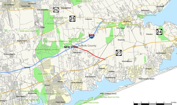 | ||
County Route 111 (CR 111) is a north–south county route in Suffolk County, New York, in the United States. It runs northwest and southeast from New York State Route 27 (NY 27) at exit 62 near Eastport to Interstate 495 (I-495) at exit 70 in Manorville. It serves as a connecting route between central Long Island and the Hamptons. The road is named for Captain Daniel Roe (1740–1820) of Selden, who served in the French and Indian War and was a captain in the Revolutionary War.
Contents
- Map of County Rd 111 Manorville NY 11949 USA
- Route description
- History
- Proposed extensions
- Safety improvements
- Major intersections
- References
Map of County Rd 111, Manorville, NY 11949, USA
Route description
CR 111 begins at an incomplete interchange with NY 27 that was intended to be upgraded from a diamond interchange to a cloverleaf with collector/distributor roads. It heads northwest through rural areas as a limited-access highway, connecting to CR 51 (East Moriches–Riverhead Road) by way of a half-diamond interchange. Just past the junction, it crosses over a long dirt road named Toppings Path. West of Toppings Path, the highway becomes a divided highway and intersects Eastport–Manor Road in Manorville. From this point on, CR 111 is an at-grade road that follows what was once Eastport–Manor Road to I-495 exit 70.
History
The current CR 111 opened to traffic in early 1975. It was intended to connect to several highways via interchanges: the east end of CR 90, the west end of the cancelled extension of CR 105, and a cancelled northern extension of CR 55 (Eastport–Manor Road). As originally planned, CR 111 would have been a 21-mile (34 km) highway extending from NY 25A and NY 3q47 in Port Jefferson Station to Montauk Highway in Westhampton Beach.
Proposed extensions
Heading southeast from NY 25A and NY 347, CR 111 was to replace Canal Road. It would then have interchanges with CR 83 (Patchogue–Mount Sinai Road) and Coram–Mount Sinai Road, where it would have broken away from Canal Road and run along its south side. CR 111 would then replace Whiskey Road west of its intersection with Miller Place–Middle Island Road and Coram–Sweezeytown Road. It would break away from Whiskey Road east of Middle Island Boulevard, cross over Miller Place–Yaphank Road, and reunite with Whiskey Road again until the proposed interchange with CR 21 (Rocky Point–Yaphank Road). CR 111 would then shift to the northeast corner of CR 21 and Whiskey Road, running parallel with Whiskey Road until north of the intersection with Currans Road, where it would cross over Whiskey Road and remain along its south side until its terminus at CR 46 (William Floyd Parkway) in Ridge.
East of William Floyd Parkway, CR 111 was intended to have an interchange and then curve south through Brookhaven State Park on land once formerly owned by the Brookhaven National Laboratory. After the interchange with NY 25, it would shift eastward along the northern border of Brookhaven Lab, crossing the Robert Cushman Murphy County Park twice. In between this Suffolk County Preserve area, it would run through the grounds of the Grumman Calverton Naval Weapons Industrial Reserve Plant. It was to then follow along Wading River–Center Moriches Road (former CR 25) before heading south again toward the Peconic River. The road would join its existing section on the northeast corner of the westbound service road on the Long Island Expressway (I-495) at exit 70.
Continuing southeast from the existing highway's southeastern end at the interchange with NY 27, CR 111 was to run southeast across the Pine Barrens. It would run roughly parallel to CR 71 (Old Country Road) before intersecting with it at the Montauk Line of the Long Island Rail Road. It was then intended to replace CR 71 as it crossed Montauk Highway and headed through the village of Westhampton Beach towards the Atlantic Ocean coastline.
Safety improvements
In the past few years, there have been renewed efforts by local residents and political leaders to reduce the high speed, unsafe conditions, and traffic that plagues CR 111, particularly during peak travel times in the summer season. Notably, as the "Gateway to the Hamptons", CR 111 carries the majority of travelers who are making their way from the Long Island Expressway (I-495) to NY 27, and vice versa. This causes perennial backups and frustrations on Friday and Sunday afternoons.
Local residents have been complaining for many years about the problem of the highway, particularly in Manorville, where CR 111 forms the backbone of the tiny hamlet and connects all of its services and stores. These complaints have crescendoed in recent years as the accident rate on the road has risen alarmingly; the latter has finally prompted attention from Suffolk County.
Through the lobbying of local representative Edward Romaine, the county is conducting the most thorough traffic studies to date. In the interim, a patchwork solution has been created by installing two brand new traffic lights at the offramps of the Long Island Expressway to control the traffic siphoning on and off. Once the peak summer season ends, the county will complete its traffic study and implement more long-term solutions, some of which may include additional or better-coordinated traffic signals, traffic calming devices, and a reduction in the speed limit of the road through Manorville's hamlet center.
Major intersections
The entire route is in Suffolk County.