
 | ||
Address 32°47'30. 111°42'18., 9 E 4th St, Casa Grande, AZ 85122, United States | ||
The Corona Satellite Calibration Targets are two hundred and seventy two concrete markers in and around Casa Grande, Arizona that helped to calibrate satellites of the Corona spy satellite program.
Contents
Background
Following the launch of Corona satellites in the 1960s, the National Reconnaissance Program (formerly known as the National Foreign Intelligence Program) determined that there was a need for calibration under the Controlled Range Network. Working with the Arizona Real Estate Office, the Army Map Service was directed to lease land for office space in Casa Grande, Arizona. Land was leased in one hundred by one hundred foot parcels, with access to a road. Large concrete Maltese crosses in the ground, sixty feet in width, and were in place by 1967. The crosses were arranged in a sixteen by sixteen grid, each roughly a mile apart from the next one.
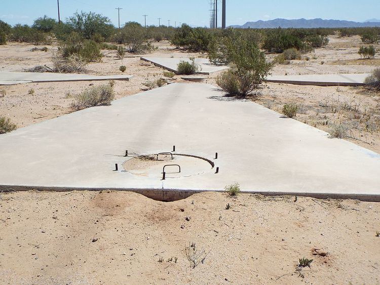
Each of the targets has a manhole or hatch on the west arm of the cross, The manhole has a cement cover and steel reinforcment bars ("rebar"). According to Gary Morgan, member of the Cold War Museum in Warrenton, Virginia, the 6 pieces of rebar, which protrude at an equal distance from each other, may have been used to hold laser lighting to give a more accurate fix on each target.
The majority of the targets were abandoned when the program ended in 1972. According to Army Map Service, the government considered the targets to be obsolete because the land on which they were situated had subsided because of groundwater extraction. Land lessees were then given the option of having the targets removed and dumped near Eloy, Arizona. At least 144 targets (counted November 2016) remain in place, unless they have been removed because the location has been redeveloped.
Images
The Corona Satellite Calibration Targets pictured in the image gallery are two of the few remaining ones in the desert. The first one is located on the southeast corner of South Montgomery and West Cornman Roads. The second one is located on the northeast corner of West Cornman Road and Carmel Blvd.