
Country United States County Habersham Cornelia October 22, 1887 Elevation 457 m Population 4,190 (2013) | Blaine 1860 Time zone Eastern (EST) (UTC-5) Zip code 30531 Local time Monday 7:58 AM | |
 | ||
Weather 9°C, Wind E at 11 km/h, 71% Humidity | ||
Cornelia is a city in Habersham County, Georgia, United States. The population was 3,834 at the 2010 census. It is home to one of the world's largest apple sculptures, which is displayed on top of an obelisk shaped monument. Notably, it was the retirement home of baseball legend Ty Cobb who was born nearby, and was a base of operation for production of the 1956 Disney film The Great Locomotive Chase that was filmed along the Tallulah Falls Railway that ran from Cornelia northward along the rim of Tallulah Gorge to Franklin, North Carolina.
Contents
- Map of Cornelia GA USA
- Geography
- History
- Early Industries
- Historical Lore
- Schools
- The Big Red Apple
- Demographics
- References
Map of Cornelia, GA, USA
Geography
Cornelia is located at 34°30′49″N 83°31′51″W (34.513716, -83.530942).
According to the United States Census Bureau, the city has a total area of 3.4 square miles (8.8 km2), all land.
History
(This section adapted from Cornelia, The First Hundred Years printed in 1987 by the Habersham Historical Society (uncopyrighted — public domain) in commemoration of the town’s centennial with minor chronological editorial updates)
The first European to visit what is now Habersham County was Hernando de Soto, who came in search of gold in 1540. He came from the southeast, around Currahee Mountain, by way of Chopped Oak (which was called "Digaluyatunyib" by the Cherokee Indians). This place was the site of an ancient oak tree which was notched by the Indians after each scalping. De Soto is thought to have traveled through Nacoochee Valley [1], crossing the Soque River near Clarkesville, and continuing on his way. A small part of the southern end of the county was probably at one time held by the Creek Indians, while the Cherokee Indians inhabited the rest of the county. The old boundary line between the Cherokee and Creek nations ran below where Chenocetah Mountain and Hillcrest are located and now lies within the city limits of Cornelia. The white men soon persuaded the State of Georgia to take the lands from the Indians. The United States government held that the State could not do so; but the spirit of local self-government was still strong in Georgia, and the state defied the federal government and took the land despite the rulings of the Supreme Court. The first treaty affecting any part of what is now Habersham County was in 1804 and concerned a tract of land "four miles in width from the top of Currahee Mountain to the north ford of the Oconee River." (Stephens County was not created until 1905.) The area is now in Banks County near Wofford Shoals. Many of the old land grants to the head right lands, now largely in the government area around Nancytown Lake [2], were granted in this period. This Treaty of 1804 is called "The Four Mile Purchase Treaty" and, although the land was originally in Franklin County, the original strip now lies in Banks and Habersham Counties because of later redistribution of land in counties.
The Blair Line was the boundary between the State of Georgia and the Cherokee Nation (now Georgia hwy 115 at junction with Georgia hwy 105). lt was named for James Blair, the surveyor that identified the exact line. In 1817, the boundary line was established for the purchase of all lands east of the Chattahoochee River from the forks of the Soque and Chattahoochee Rivers in a direct northerly line to the Tallulah River. The Treaty of 1818 completed the purchase by the State of Georgia. Highway US 23 and US 441 runs along the divide between the Atlantic Ocean and the Gulf of Mexico. As previously stated, it was the boundary line between the Cherokee and Creek Indian nations. Along this ridge ran the Indian War Trail, from a Cherokee settlement on the upper Tugalo to what is now Atlanta. A branch went southeast into the Creek nation.
At the close of the Civil War in 1865, the section where Cornelia is now located was a typical mountain forest. The spot was so well secluded that a moonshine still was operated without interference at the site of what is now the center of downtown — the Southern Railway station (Tri-County Advertiser, June 16, 1927). Cornelia was first settled around 1870. lt was situated near the old boundary line between the Cherokee and Creek Indian tribes, the Cherokee land extending to the north and the Creek land to the south. ln 1872, workers of the Atlanta and Richmond Air-Line Railway (later Charlotte-Airline; today's Southern Railway) invaded the virgin forest. A roadbed was cleared and graded, and tracks were laid from Gainesville to Toccoa. In 1882, the Blue Ridge and Atlantic Railroad opened a line which extended northward from the Charlotte-Airline to Clarkesville and Tallulah Falls. The Tallulah Falls Railway, as it came to be called, carried passengers, freight, and mail from Cornelia to Franklin, North Carolina. Many of the passengers rode to view Tallulah Gorge, which was one of the most scenic spots in northeast Georgia. Later, the railway served a more utilitarian purpose, until after World War II, when the line was discontinued.
At first the settlement at the junction of the railroads was called Tom Paine's Post Office. From the day when the railroad began operations, there were signs of building activities in and around the area. With the help of a friendly judge, who was also the attorney for the Blue Ridge Railroad, a local man named Henry Smith had the junction of the two railways moved so that it was adjacent to this property. Then Mr. Smith superimposed a gridiron street pattern on his property to form blocks. The blocks, in turn, were subdivided into building lots. To ensure the success of his speculative venture, the owner deeded every other block to the railroad in return for moving its tracks and sold lots on the remaining blocks to railroad employees. The owner of the property on the opposite side of the tracks followed suit by subdividing and selling his property. lt, too, was platted in a grid pattern. These two subdivision plats form the original plan for the town of Cornelia, complete with narrow streets and no provision for parks or other amenities. The plat shows streets laid out parallel to the property boundary lines, which were roughly parallel to the railroad. The square blocks which lie east and northeast of the central business district of Cornelia represent the original town. The railroad depot was originally called Blaine for the Republican presidential candidate James Gillespie Blaine, but the cluster of houses was called Rabun Gap Junction. When the first charter of the town was secured by an attorney representing the railroad (Middleton P. Barrow), the name was changed to Cornelia in honor of his second wife (and daughter of Confederate Major General Henry R. Jackson), and so it has remained. Cornelia’s official date of incorporation was October 22, 1887. The state defined its boundaries by inscribing a circle with a radius of one-half mile. Logically enough, this inscribed circle was centered on the railway station.
In 1895, J. A. Reynolds, a local land surveyor and town planner, made a city plan of Cornelia for the Broadview Park Land and lmprovement Company for Cornelia. This plan follows Mr. Reynolds' ideas for Demorest and includes curvilinear streets, parks, and lakes. There was an attempt to carry out this plan, as Cornelia's perimeter road which follows the circular boundary and the large city park were components of Mr. Reynolds' plan. The plat of this improvement plan for Cornelia is on file in the Habersham County Courthouse in Clarkesville. In addition to being the official town plat, it is also an advertisement for selling lots in Cornelia. Advertising on this plat is identical to that carried on the original plat for the town of Demorest, which entices prospective buyers with promises of clean mountain air, fresh water, scenic views, medicinal springs, business opportunities in timber and mining of iron ore, and handsome profits on investments in land located in Cornelia. According to the June 16, 1927, issue of the Tri-County Advertiser, Thomas Capps and Thomas Paine established the first business house of any importance in the struggling village. lt grew and prospered until the year 1884, when Peter King and L T. Sellers bought the business and operated it for more than twenty years. They later sold it to L.Y. lrvin, who operated the business as one of the largest department stores in this section of the state. Early subdivision development in Cornelia continued at least until 1912. A plat for the Clear-View Subdivision was filed with the county in 1909, and the Park View Heights Subdivision plat was filed in 1912.
Cornelia is built on the falling slopes of seven hills which collect together to form a group of Georgia's highest mountains, the Blue Ridge Mountains. Cornelia is actually an intrusion of the generally flat, rolling upper Chattahoochee River Plateau and the beginning of the Georgia Mountain Region. The elevation of the town is 1,580 feet above sea level. Located on hills and dales, there are many springs and streams. Lake Russell, named for the late Honorable Richard Russell, Jr., former Governor and United States Senator, is composed of a long shoreline and is about one and one-half miles wide. It lies between Chenocetah Mountain and Currahee Mountain in part of the land contained in the Four Mile Purchase of 1804.
Early Industries
The first industry in Cornelia was a tanyard located on the banks of Tanyard Creek on the highway from the mountains to Athens. During the early 19th century, the area became a shopping center when covered wagons, crossing the mountains en route to Athens, stopped at this tanyard to sell or exchange their goods for leather to be made into various articles. Other early industries were the result of the immigration to the area around 1880 of large numbers of Germans and Swiss. Although many were cobblers, watchmakers, and weavers, most of them were farmers and winemakers. Winemaking flourished until the State of Georgia adopted a strict prohibition law, and the vineyards were cut down to make room for farming. Much of the farmland in the area was cultivated into cotton fields. A cotton gin (known as "Hoppers”) was locally owned and operated on the Cornelia-Clarkesville Highway. Among the men prominent in the early history of the town were Thomas Kimsey, Perry Blackburn, J.A. Walker, J.L. Maxwell, B.W. Grant Sr., and C.H. Sellers. A number of small businesses began to spring up around the junction, and there was a steady growth. Industries which flourished later were timber and lumber products and the cultivation of apples and peaches. J.P. Shore built the first sawmill. Colonel John Porter Fort [3], along with other Georgians, promoted the cultivation of apples and peaches by sending samples of the fruits to enter into competition at the Washington State Fair in 1905. The superb flavors were noted and given first prize with highest honors, thereby gaining national recognition.
In 1890, gristmills were owned by P.R. Kinsey, T.J. Warren, and A.P. Wofford. J.C. Edwards and W.M. Stott operated hotels. J.M. Biggers and P.G. Payne were shoemakers, and Joe Poe was the town's blacksmith. General stores were King and Sellers, and W.M. Stott's. J.C. Edwards was Justice of the Peace. W.S. Echols was Bailiff and W.N. Harden was a lawyer and the town's depot master. Hotel owners in the town contributed a great deal to the growth and development of Cornelia. According to one source, the first hotel in the town was operated by Oliver Wyley, with Worth Grant coming soon after to open the Grant Hotel. After the burning of the hotel operated by Mr. Wyley, Mr. Grant bought its lot and built a large, modern hotel which he operated very successfully for a number of years. By advertising that it served chicken pie 365 days a year, he made it one of the most popular hotels between Atlanta and Charlotte. About 1912 he sold the hotel to Joseph W. Jackson, who operated the place as the 'Commercial Hotel'. At about the same time, the Stovall Hotel was erected on the site of the first Grant Hotel. (History and Resources of the Hills of Habersham County, published by Department of Education, Clarkesville, Georgia, 1937, pp. 19–20.) About the year 1900, business dealings became more active. Officially, the 1900 census listed 1,058 inhabitants in the district of Cornelia. Of these, 467 resided within the city limits. lt was in that year that W.S. Witham, J.W. Peyton, l.T. Sellers, and others organized and opened for business the Cornelia Bank [4] with a gain in capital of $15,000. In 1909, the First National Bank was organized and opened for business with a paid-in capital of $30,000 by C.J. Hood, C. W. Grant, G.B. lrvin, P.Y. Duckett, and others. About the years 1910-1912, bonds were issued and a system of waterworks and sewerage was installed.
ln 1903, a disastrous fire occurred in the town and practically cleaned out all the frame structures in the block across from the railroad station. In 1904, Martin and Oakes purchased the lots made vacant by the fire and erected the corner building now occupied by the Cornelia Pharmacy. These gentlemen sold their interests to W.l. Stovall, who continued to develop the block. Many believe that the interest and development by Mr. Stovall contributed to the ongoing growth of the town more than any other individual at this time (Tri-County Advertiser, June 16, 1927.) About 1906, the Postal Telegraph surveyed and built a telegraph line from Atlanta to Washington, DC, and, as most of their lines were constructed along streets and highways, they erected their lines through Cornelia on the east side of Foreacre Street to Jones Street and the Toccoa Highway (Thls Yonah of Yesteryear by R.L. Maxwell, p. 4.) J. Archie Willis, who featured Cornelia in an article in the Atlanta Journal (August 4, 1918), stated that "Cornelia hospitality is the result of its having been built. . . by men and women to whom the spirit of hospitality comes naturally. They're glad to see new people in Cornelia, and they know how to make one feel they are glad to have the visit with them." In the same featured story, the following facts about Cornelia were mentioned: 1. Has sixteen passenger trains per day 2. Boasts of four peach packing plants and two apple packing plants 3. Has two planning mills, a cotton ginnery, two grist mills, and a roller mill 4. Has automobile repair shops and blacksmith shops 5. Possesses a wagon manufacturing plant 6. Owns a local telephone system with 300 residence phones (at $1.50 per month) and 65 business phones (at $2.00 per month) 7. Sends 400 children to school, which has at least 10 teachers. L.Y. lrvin is listed as mayor, with the Town Council being composed of J.M. Gillespie, W.B. Parks, Plumer Duckett, G.R. Brown, and M.N. Crow. In 1946, Johnson & Johnson built a textile manufacturing plant in Cornelia under the name Chicopee. In 1980 the site was transferred to Ethicon, another Johnson & Johnson company that manufactures sutures and surgical needles.
Historical Lore
Cornelia abounds in historical lore. Near the city is the Wofford Trail [5], upon which many a stagecoach robbery occurred. The last railroad holdup in Georgia took place at Cagle's Crossing, which is a few miles south of Cornelia. The whole of Habersham County was extremely loyal to the Confederacy and was known, along with the Shenandoah Valley of Virginia and countless other fertile, out-of-the-way places as the "breadbasket of the Confederacy", as thousands of bushels of wheat and corn were supplied to the troops from this area alone. After the fall of Atlanta, a detachment of Sherman's cavalry was sent to raid the county; but the Confederate Home Guard, made up of men too old for military duty, left the mountains on which Cornelia is situated and met the Yankee raiders at a narrow pass about four miles east of the town. By making considerable noise and stirring up clouds of smoke, they scared off the enemy and saved the area from complete devastation. Today this skirmish is remembered as 'The Battle of the Narrows'.[6] A few years after the war, a young school teacher named William Herschel Cobb and his wife Amanda settled near the site of this skirmish, and she gave birth in 1886 to one of the greatest baseball players of all time, Ty Cobb.
Schools
Cornelia has been helped in its growth by its good schools. In the early days, the school system was owned and operated by the town of Cornelia. Each student provided his books and paid a tuition fee, half payable before Christmas with the balance due after Christmas. The school principal would determine what books would be needed and would then send someone to Atlanta to order books and supplies personally from the publishers (Maxwell, p. 4). Among the first schools was the Kimsey Institute, located on land given by T.J. Kimsey. The First Baptist Church was organized there; for many years it was used for both school and church. Willie Grant and J.T. Wise were two of the early teachers. After attendance outgrew the early frame building in 1897, another school was built with Professor A.E. Booth elected as principal. According to the document published by the Habersham County Department of Education in 1937, Professor Booth added a training course for teachers, and students were attracted to this school from all sections of northeast Georgia (p. 21). Cornelia Normal Institute was chartered on May 27, 1901. lt was supported by many progressive citizens, including D.A. York, J.T. King, J.A. Walker, W.D. Burch, L.J. Ragsdale, J.T. Peyton, L.L. Lyon, J.W. Peyton, J.J. Kimsey, l.T. Sellers, J.C. McConnell, J.W. McConnell, A.J. Brown, R.C. Moss, T.S. Wells, John S. Crawford, George Erwin, and J.C. Edwards. In 1952, the schools in Habersham were consolidated. The elementary schools had been kept in each town but two high schools were built, one to serve each end of the county. Prior to 1952, Cornelia Public School served all the students residing in Cornelia. The high school curriculum included college preparatory and business classes, athletics for both males and females, music, and "expression" (speech classes). The school's first graduates were in the Class of 1899 and included Martin L .York, Charles Crunkleton, Calvania T. York, Albert N. McConnell, Wylie G. Light, and lda K. Baugh.
German and Swiss immigrants used their wine-making skills to create an industry in the 1880s that flourished until a prohibition law stopped it. Cotton, timber and lumber products, and the apple and peach industries were also important to the success of the area. Riegel Textile built one of the region's first major industrial facilities in 1966 with what was then an ultra-modern, cutting edge textile mill designed by Bill Pittendreigh in then neighboring community of Alto, Georgia. As with any city, there were a number of businesses, but hotels contributed greatly to the growth and development of the city in its early history.
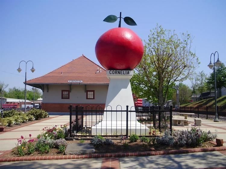
The Big Red Apple
Cornelia's Big Red Apple, located at the old train depot in downtown, pays homage to the apple and apple growers of the county. Built of steel and concrete in 1925 the statue, according to Habersham County, The Big Red Apple weighs 5,200 pounds (2.4 t) and is 7 feet (2.1 m) high.
Towards the end of World War I, "Extension agents" began to play a very important role in northeast Georgia. These people, as a group, supported the end of the one-crop (cotton) economy. Throughout the state they began to educate farmers in crop diversification so that if one crop failed income from other crops could support the family. In Gwinnett, Cherokee and Hall County, farmers increased production of dairy products. The peach crop in Bartow County was expanded. In Habersham and Gilmer Counties farmers increased production of apples and peaches.
The Extension Agents push for this diversity seemed almost prescient, for in 1922 the boll weevil began the systematic destruction of cotton crops in the state of Georgia. By 1924 cotton output had dropped to 50% of earlier levels. In 1925 the people of Cornelia realized that the apple had been a key in preventing the scourge that destroyed other counties and drove rural families to cities like Atlanta and Macon. The concept for the statue was born, thanks in part to the newly formed Kiwanis Club.
At the dedication on June 4, 1926 many notables attended, including Senator Walter F. George. This however, is not the end of the apple crop story. Because apple sales were off dramatically in 1932 local farmers decided to put them in cold storage until the following Spring, but the sales did not materialize, so the farmers were not only out the cost of raising the crop, they were also out the cost of storing the crop. By the summer of 1933, the apples that had saved the county less than 10 years earlier nearly destroyed it.
Through the years downtown Cornelia changed dramatically. As the railroad era passed the old depot was closed and boarded up, and the once central location was only a side street. A recent renovation has brought the depot back to life and the quiet Big Red Apple is the focal point of a yearly festival held the first week in October and a 5K road race held at the end of October.
Demographics
As of the census of 2010, there were 4,160 people, 1,495 households, and 1,495 families residing in the city. The population density was 1,071.3 people per square mile (413.6/km²). There were 1,728 housing units at an average density of 469.7 per square mile (181.3/km²). The racial makeup of the city was 67.7% White, 5.7% African American, 0.9% Native American, 4.2% Asian (3.0% Laotian), 0.6% Pacific Islander, 16.5% from other races, and 4.4% from two or more races. Hispanic or Latino of any race were 34.8% of the population (26.7% Mexican).
There were 1,016 households out of which 24.4% had children under the age of 18 living with them, 47.4% were married couples living together, 12.6% had a female householder with no husband present, and 35.6% were non-families. 32.1% of all households were made up of individuals and 17.5% had someone living alone who was 65 years of age or older. The average household size was 2.47 and the average family size was 3.09.
In the city, the population was spread out with 23.4% under the age of 18, 11.0% from 18 to 24, 26.4% from 25 to 44, 21.7% from 45 to 64, and 17.5% who were 65 years of age or older. The median age was 37 years. For every 100 females there were 93.8 males. For every 100 females age 18 and over, there were 89.2 males.
The median income for a household in the city was $31,111, and the median income for a family was $42,041. Males had a median income of $25,505 versus $20,404 for females. The per capita income for the city was $21,701. About 8.8% of families and 13.3% of the population were below the poverty line, including 15.1% of those under age 18 and 20.2% of those age 65 or over.