
Highest point Uturunku | ||
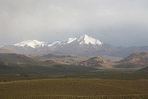 | ||
Mountains Uturunku, Cerro Lípez, Cerro Panizos | ||
The Cordillera de Lípez is a mountain range in northern Potosí, Bolivia, and northern Argentina, part of the Andes. The range covers an area of 23,404 km² (9,036 sq mi) and runs in a northeast-southwest direction, between the parallels 22 degrees and 23 degrees, helping to form the boundary between Bolivia and Argentina. Thus the Cordillera de Lípez is a transverse range in the Andes, between the Cordillera Oriental and the Cordillera Occidental, creating the southern boundary of the Bolivian Altiplano.
Map of Cordillera de Lipez, Bolivia
The highest peak is Uturunku at 6,008 m (19,711 ft). Other important peaks are Cerro Lípez (5,929 m) sometimes misidentified[1] as Nuevo Mundo; Soniquera (5,899 m) (sometimes misspelled as Soreguera); and Tinte (5,849 m) which is on the Bolivian-Argentine border. Despite the high elevations, there is no current glacier activity in the Cordillera de Lípez, just some semi-permanent snow fields.