
Peak Cerro Tatamá Elevation 4,764 m | Area 86,239 km² | |
 | ||
Length 1,200 km (750 mi) north-south | ||
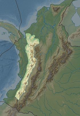
The Cordillera Occidental (English: West Andes) is the lowest in elevation of the three branches of the Colombian Andes. The average altitude is 2,000 m (6,600 ft) and the highest peak is Cerro Tatamá at 4,100 m (13,500 ft). The range extends from south to north dividing from the Colombian Massif in Nariño Department, passes north through Cauca, Valle del Cauca, Risaralda, Chocó, and Caldas Departments to the Paramillo Massif in Antioquia and Córdoba Departments. From this massif the range divides further to form the Serranías de Ayapel, San Jerónimo and Abibe. Only to recede into the Caribbean plain and the Sinú River valley.
Contents
Geography
The western part of the mountain range belongs to the Pacific region, with the San Juan River being the main watershed, while the eastern part belongs to the Cauca River basin. The northern and northwestern parts belong to the Atlantic Slope, with the Atrato and Sinú Rivers being the main watersheds. The Cordillera Occidental is separated from the coastal Baudó Mountains by the Atrato River.
Highest Peaks
Protected Areas
The West Andes have the following nationally protected areas from south to north:
Other areas under consideration for national protection include: