
Peak Cerro de Punta Highest point Cerro de Punta | Elevation 4,390 ft (1,340 m) Country Puerto Rico | |
 | ||
Mountains Cerro de Punta, Monte Guilarte, Cerro Maravilla, Tres Picachos, Cerro Dona Juana | ||
Cordillera Central (English: Central Mountains range), is the main mountain range in Puerto Rico. The range crosses the island from west to east and divides the island into northern and southern coastal plains.
Contents
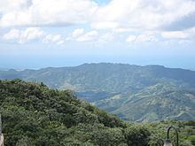
- Map of Cordillera Central Jayuya 00664 Puerto Rico
- Mountains in the Cordillera Central range
- References
Map of Cordillera Central, Jayuya 00664, Puerto Rico
Cordillera Central runs eastward from Maricao in the west to Aibonito in the central eastern Puerto Rico region and on to the outskirts of the Sierra de Cayey. Sierra de Cayey is an extension of Cordillera Central that begins in the town of Cayey and runs eastwardly to Humacao. The Sierra de Cayey "extension" ends in a fork with two lower ranges: Sierra Guardarraya and Cuchillas de Panduras which run eastward to Yabucoa and Patillas respectively.
Another Cordillera Central eastern branch, Sierra de Luquillo, runs northeastwardly from Gurabo to Fajardo and includes several high peaks, including Toro Hill, at 1,074 m (3524 ft), El Yunque at 1,065m (3,494 ft) and El Pico Oeste at 1056 m (3446 ft).
Mountains in the Cordillera Central range
& = Not in Cordillera Central. Placement here for reference only.