Supriya Ghosh (Editor)

Cordillera Central (Colombia)

Updated on
Edit
Like
Comment
Share on FacebookTweet on TwitterShare on LinkedInShare on Reddit
Peak
  
Nevado del Huila

Area
  
129,737 km²

Country
  
Colombia

Elevation
  
5,364 m

Highest point
  
Nevado del Huila

Cordillera Central (Colombia) httpsuploadwikimediaorgwikipediacommonsthu

Length
  
1,023 km (636 mi) north-south

Mountains
  
Nevado del Ruiz, Nevado del Huila, Nevado del Tolima, Santa Isabel, Nevado del Quindío

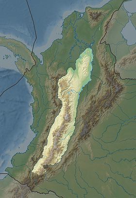
The Cordillera Central (English: Central Andes) is the highest of the three branches of the Colombian Andes. The range extends from south to north dividing from the Colombian Massif in Cauca Department to the Serranía de San Lucas in Bolivar Departments. The highest peak is Nevado del Huila at 5,364 m (17,598 ft).

Contents

Map of Cordillera Central, Pereira, Risaralda, Colombia

Geography

The range is bounded by the Cauca and Magdalena river valleys to the west and east, respectively.

Highest Peaks

  • Nevado del Huila - 5,364 m (17,598 ft) - Cauca, Huila & Tolima
  • Nevado del Ruiz - 5,311 m (17,425 ft) - Caldas & Tolima
  • Nevado del Tolima - 5,215 m (17,110 ft) - Tolima
  • Nevado de Santa Isabel - 5,100 m (16,700 ft) - Risaralda, Tolima & Caldas
  • Nevado del Quindio - 4,760 m (15,620 ft) - Quindio, Tolima & Risaralda
  • Cerro Pan de Azucar - 4,670 m (15,320 ft) - Cauca & Huila
  • Puracé - 4,646 m (15,243 ft) - Cauca & Huila
  • Protected Areas

  • PNN Los Nevados
  • PNN Nevado del Huila
  • PNN Puracé
  • PNN Las Hermosas
  • PNN Selva de Florencia
  • SFF Otún Quimbaya
  • SFF Serranía de las Minas - proposed
  • References

    Cordillera Central (Colombia) Wikipedia