
Length 20 km | Source Southern Alps Country New Zealand | |
 | ||
Main source Southern Alps1,180 m (3,870 ft) River mouth Karangarua River52 m (171 ft) | ||
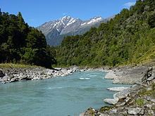
Auto draw 2 copland river above welcome flats westland national park new zealand
The Copland River is a river on the West Coast of the South Island of New Zealand. It flows for 20 kilometres (12 mi) from its headwaters in the Southern Alps to its confluence with the Karangarua River.
Contents
- Auto draw 2 copland river above welcome flats westland national park new zealand
- Map of Copland River West Coast New Zealand
- References
Map of Copland River, West Coast, New Zealand
The headwaters of the Copland lie only 8 kilometres (5 mi) northwest of Aoraki / Mount Cook in a valley overlooked by the peaks of Mount Sefton and Mount La Perouse. A popular tramping track follows the river and leads to the Welcome Flat hot springs. The track leads onto the Copland Pass and the Copland Glacier.
The river lies within the Westland Tai Poutini National Park.
References
Copland River Wikipedia(Text) CC BY-SA