
Established 1998 Time zone ACST (UTC+9:30) Mean max temp Mean min temp Postal code 5264 | Postcode(s) 5264 Founded 1998 | |
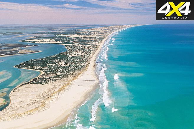 | ||
Coorong is a locality in the Australian state of South Australia which is associated with the lagoon known as the Coorong in the south-east of the state and which overlooks the continental coastline from the mouth of the Murray River about 80 kilometres (50 mi) south-east of the state capital of Adelaide to the immediate north of the town of Kingston SE extending for a distance of at least 140 kilometres (87 mi).
Contents
Map of Coorong SA 5264, Australia
It extends from the Murray Mouth in the north to the northern end of the Paranki Lagoon in the south including:
The boundaries of the locality were created firstly for the part within the Kingston District Council in 1998 and secondly for the part within the Coorong District Council in 2000 including the Villa De Yumpa Shack Site. The name is reported as being derived from the lagoon of the same name. The boundary with the locality of Hindmarsh Island was altered in 2014 to move Bird Island, an island located north-east of the Murray Mouth, into the locality of Coorong.
The principal land use in Coorong is conservation with the majority of the land being occupied by the Coorong National Park and the Mud Islands Game Reserve.
The locality includes the following state heritage places: Magrath Flat Homestead, Teeluc Cottage and White Hut Cottage
Coorong is located within the federal Division of Barker, the state electoral district of MacKillop and the local government areas of the Kingston District Council and the The Coorong District Council.
Surrounding localities
Coorong is bounded in the sector from the west to the south by the body of water known in Australia as the Southern Ocean and by international authorities as the Great Australian Bight and bounded from the north-west to the south-east by the following localities gazetted under the South Australian Geographical Names Act 1991: