
OS grid reference SO8480 Post town KIDDERMINSTER Local time Sunday 9:08 PM | Sovereign state United Kingdom Postcode district DY11 UK parliament constituency Wyre Forest | |
 | ||
Weather 4°C, Wind NW at 24 km/h, 92% Humidity | ||
Cookley holiday clubs 1971 1972
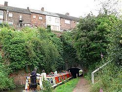
Cookley is a village in the Wyre Forest District of Worcestershire, England, a few miles to the north of Kidderminster, and close to the villages of Kinver and Wolverley. It lies on the River Stour, and the Staffordshire and Worcestershire Canal in the civil parish of Wolverley and Cookley. At the time of the 2001 census had a population of 2,491.
Contents
Map of Cookley, Kidderminster, UK
Commerce within the village include a butchery, a post office and a tandoori take away – all of which are family-run. It also has a Tesco Express.
Saxon estate
The name Cookley was originally Culnan Clif, a place for which there is a Saxon charter with a boundary clause covering a substantial part of the northern part of the parish of Wolverley and Cookley. The medieval village of Cookley lay on the opposite side of river Stour to the present village, next to Caunsall. It gave its name to Cookley Wood, a former common, also known as Blakeshall Common. Blakeshall was thus also part of the Saxon estate. The estate was granted by William I to Worcester Cathedral Priory, which already owned the adjoining estate of Wolverley. From that time, the two were administered together as the manor of Wolverley. Nevertheless, the Domesday Book extent of Wolverley can be explained in terms of the preceding Saxon estate of Wolverley only.
Cookley Forge
The present village of Cookley developed near Cookley Forge, a water-powered finery forge on the river, just west of the bridge. The forge was initially a slitting mill established in about 1639, replacing a corn mill. The forge was probably added in the 1670s, and was one of the works of the Foley family's "Ironworks in Partnership" in the 1690s.
The forge passed before 1725 to the Knight family and remained in their hands until it closed in the late 19th century. Operations at the forge seem to have been expanded in the early 19th century, tinplate production being added. In this period, the Knight family concentrated their operations around Cookley Forge, disposing of or closing other works. This works became the main employer in the area. It prospered in the canal era. With the Staffordshire and Worcestershire canal, running beside the works and a canal arm leading into them, the canal was the main transport artery for the works. However, later in the 19th century, in the railway era, the works were at a competitive disadvantage, because there was no connection to a railway. Ultimately, the works at Cookley were closed and relocated to the Cookley Works at Brockmoor near Brierley Hill in 1886. The site of the forge has remained in industrial use, at one period being occupied by Steel Stampings Ltd.
The present village began with houses built by the Knight family for their workers and the division of fields along Castle Road into house plots, starting in the 1810s with Portway Piece in Austcliffe.