
Division B (BMT/IND) Platforms 4 island platforms Rebuilt 23 May 2004 Tracks 8 | Structure Elevated Borough Brooklyn Locale Coney Island | |
 | ||
Line BMT Brighton Line
IND Culver Line
BMT Sea Beach Line
BMT West End Line Services D (all times)
F (all times)
N (all times)
Q (all times) Transit connections NYCT Bus: B36, B64, B68, B74, B82 Address Brooklyn, NY 11224, United States Similar Coney Island, Astoria–Ditmars Boulevard, Jamaica–179th Street, Atlantic Avenue–Barclays Center, 34th Street–Herald Square | ||
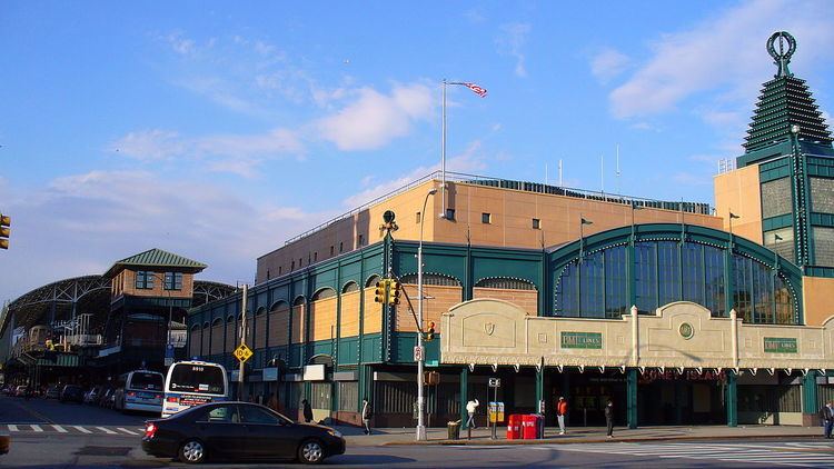
Coney Island–Stillwell Avenue (also known as Coney Island Terminal and signed on some trains as either Coney Island or Stillwell Avenue) is a New York City Subway terminal in Coney Island, Brooklyn, acting as the railroad-south terminus for the D, F, N, and Q trains. The large facility, originally built in 1919, was designed at a time when Coney Island was the primary summer resort area for the New York metropolitan area, with all of the rail lines in southern Brooklyn funneling service to the area.
Contents
- Origins
- New West End Terminal
- Renovation of the station
- Station layout
- Station house
- Solar panels
- Services and tracks
- Bus terminal
- Subwaybus transfer coordination
- Nearby points of interest
- References
The station has eight tracks and four island platforms, with trains entering from both compass north and south. It is located at the corner of Stillwell and Surf Avenues in Coney Island, the site of the former West End Terminal. Geographically, it is the southernmost terminal in the New York City Subway system.
Origins
Rail transportation to Coney Island had been available since 1864. The Brooklyn, Bath and Coney Island Railroad was the first steam railroad to Coney Island. It ran from Fifth Avenue and 36th Street in what is now Sunset Park, to its West End Terminal, at the present-day Coney Island Terminal's location, along what is now the right-of-way of the West End Line. The nearby Culver Depot, along the Atlantic Ocean waterfront near the site of the present-day West Eighth Street station, served the Brooklyn, Flatbush, and Coney Island Railway (now the Brighton Line) and Prospect Park and Coney Island Railroad (now the Culver Line). Other rail transportation included the Manhattan Beach Railroad; the Sea Beach Railroad; the Coney Island and Brooklyn Railroad; and Long Island City via the Long Island Rail Road.
These railroads were not all connected to each other, resulting in a series of spur lines crossing the island. However, the Brighton, Culver, Sea Beach, and West End railroads were acquired by the Brooklyn Rapid Transit Company (BRT) by the late 1890s, and the Dual Contracts, signed in 1913, allowed many more subway lines to be built within New York City, which had been incorporated fifteen years prior.
New West End Terminal
In the late 1910s, a completely reconstructed New West End Terminal (which gradually became better known as Coney Island Terminal) was built on an elevated structure. The new terminal consolidated the terminals of all the former steam railroad lines terminating at Coney Island except the Long Island Rail Road-controlled New York and Manhattan Beach Railway. This new terminal could accommodate hundreds of thousands of passengers a day. This project entailed rerouting the Brighton and Culver Lines from a ground-level alignment to an elevated structure with four tracks and eight platforms.
The BRT-operated Sea Beach Line, which served the terminal, opened on September 5, 1917, and the BRT West End Line had been similarly inaugurated on December 23, 1918. The terminal officially opened on May 29, 1919, when the new Brighton Line opened. With the opening of the Culver Line on May 1, 1920, the terminal was finally completed.
As a result of the Culver Line extension, the BRT's fare was cut from 10 cents to 5 cents, and Coney Island became a much more affordable vacation area compared to in previous years. In 1923, these lines came under the control of the Brooklyn–Manhattan Transit Corporation (BMT), the BRT's successor company. Riders at the new station were promised trains that ran every three minutes during rush hours, but this quickly proved not to be true. In 1923, a reporter for the Brooklyn Standard Union observed that rush hour trains had headways of eight minutes on the Sea Beach Line and fifteen minutes on the West End Line, and that no direct Manhattan service was being run on either the Brighton or Culver Lines during rush hours.
In 1929, the BMT announced a new entrance for the station. This new entrance would have retail space that would be "periodically inspected." In June 1933, a new Brighton–Franklin weekday service was announced. This service would operate express (except in evening rush hours) providing a direct route from Franklin Avenue to Coney Island. Culver elevated trains would operate to either Sands Street or Park Row depending on the time of day.
There was a transfer from the Coney Island Terminal to the Norton's Point Trolley to Sea Gate, via an elevated footbridge across Stillwell Avenue to the elevated trolley station. In 1948, the trolley was discontinued because it duplicated another trolley along a similar route (namely the McDonald Avenue Line). The trolley ramp spanning Stillwell Avenue and West 15th Street was torn down around this time.
Matters became more complicated in 1954, when the Independent Subway System (IND) started operating D trains on the Culver Line. At the time, the tracks had lettered names (i.e. Track A, Track B, all the way to Track H from east to west). However, the IND also used lettered designations for its routes (i.e. A, B, all the way to H as well). The BMT had used numbered route designations up to this point, so this had not been a problem. However, the D route was now using the Culver Line, which departed from tracks E and F. To avoid confusion, the tracks were renamed with numbered designations, which they still carry.
In 1956, residents of Coney Island protested against paying a transfer to the bus on Mermaid Avenue (now the B74 bus to Sea Gate), with some saying that the 15-cent fee for transferring should be abolished because the bus was essentially an adjunct to the station. In 1979, the City Planning Commission proposed something similar, in that Coney Island residents would get a free transfer between the B36/B74 bus routes and the subway station. It was noted that the station was the only one that did not get a free bus transfer after the corresponding subway transfer was discontinued (in sharp contrast to the BMT Culver Line, BMT Myrtle Avenue Line, and IRT Third Avenue Line, which were discontinued but replaced by bus transfers). The free transfers would allow a $200 million apartment complex nearby, funded by the government, to get more residents to move in, as well as diversify Mark Twain Junior High School and attract a stable middle class.
Schedules showing trains' departure times were installed at the Coney Island Terminal in 1965.
Renovation of the station
Once a grand hub, the Coney Island Terminal had started deteriorating by the 1960s. By 1980, the entire system was in a state of disrepair, and the terminal was no exception. It was slated to be rebuilt that year. According to the New York Daily News, the renovated station would get "a bright, new airy look" as well as one of the system's first installations of continuously welded rail. The steel and concrete station was badly corroded by the effects of salt water and poor maintenance.
In the 1990s, the Metropolitan Transportation Authority (MTA) finalized plans to overhaul the station completely. In 1999, the MTA requested $125 million in federal funding for the renovation. As part of renovation, a group of satellite dishes was proposed for the station. By this point, the New York City Transit Police were operating from a tent adjacent to the station, and there were vestiges of a carousel within the station.
Renovation started in November 2001. During this time, Coney Island Terminal was given a full, $310 million reconstruction, with one platform at a time for the West End W train remaining open during construction. The original BMT station building facade was restored, and a new roof with solar panels was installed, as part of this renovation. The new terminal opened on May 23, 2004, with 6 tracks and the restoration of F and Q services. The project completed on May 29, 2005, with full restoration of N service, the replacement of the W route with the D route on the West End Line, and all eight tracks in service. The accelerated 42-month schedule, as well as the partial service from the West End Line throughout construction, was largely to minimize impact on the surrounding community.
In May 2010, the station received four new electronic 32-inch (81 cm) train departure boards for each platform. These boards are controlled by dispatchers based on the departure times posted on subway timetables.
In the aftermath of Hurricane Sandy in 2012, the station house was flooded, and some electrical equipment was damaged.
Station layout
The station has eight tracks and four island platforms. According to the MTA, the station is one of the world's largest elevated transportation terminals as well as the most energy-efficient mass transit facility in the United States. The westernmost tracks, tracks 5–8, gradually slope downward, so tracks 1–4 are slightly higher than tracks 5–8 at the station's south end. There are ADA-compliant ramps from the three easternmost platforms (the Culver, Brighton, and Sea Beach Lines' platforms, respectively) to the main station building below the platforms; a non-ADA-compliant ramp leads from the West End Line (eastern) platform, with steps. An ADA-compliant elevator at the northern end of the West End Line platform leads to an overpass that connects to another ADA-compliant elevator at the northern end of the Sea Beach Line's platform. There are also stairways down to the station building. The southern two-thirds of the station is under the solar-panel-covered roof, while the northern third of the station is in the open air, not covered by anything. The shed is lit up by platform floodlights during the night hours.
The solar-paneled roof was designed by Kiss and Cathcart Architects and the new station's structural engineering was designed by Jacobs Engineering Group. Both the roof and the station itself built by a joint venture between Granite Halmar Construction and Schiavone Construction. The new station recycled 85% of the materials from the old station, and 2,000,000 pounds (910,000 kg) of steel was salvaged from the old station for use in the new terminal. However, the station was almost completely rebuilt, and a brick signal tower is all that remains of the old station. The station has train crew facilities at its north end.
The 2004 artwork at this station is My Coney Island Baby by Robert Wilson. The artwork consists of silk screen prints along a 370-foot (110 m) section of the station's glass bricks that feature beach-related scenes, especially scenes related to Coney Island's history.
Station house
The station house, called the Portal Building, was designed by di Domenico + Partners and built by Vertex Engineering Services. The three-floor, 34,000-square-foot (3,200 m2) Portal Building, located at 1243 Surf Avenue, has a terra cotta facade in imitation of the former terminal, including restored BMT signs and logos, and a parapet salvaged from the original station house. The building's design is supposed to evoke the area's amusement park-based history, with small lights hanging from the narrow, articulated tower that rises next to the station entrance. There are also art deco lamps and a semicircular window that fills an arch above the station entrance.
The Portal Building's main entrance is on Surf Avenue past the station's south end. From this entrance, there is a police precinct (Transit District 34 of the New York City Police Department), retail space, and the station's fare control area. There is also another entrance/exit to the bus shelter on Mermaid Avenue. The retail space and the new station entrance were built during the 2001–2005 renovation. There is also a side entrance from Stillwell Avenue itself.
There are also High Entry-Exit Turnstiles that allow entry to the station during late night hours, when the station booth is closed.
Solar panels
The new station's infrastructure includes a soaring roof with arches reminiscent of grand European railway stations such as the Gare Saint-Lazare and the Paddington railway station. The roof is glazed with photovoltaic (solar electric) panels, consisting of 2,730 thin-film modules from Schott AG and covering a surface of 76,000 square feet (7,100 m2). The solar panel system has a nominal power of about 210 kWp, which generates an annual output of 250,000 kWh, which the station can use to offset power needs. The solar panels provide only about 15% of the station's power, however.
Due to their location near the beachfront, the station roof's solar panels needed to meet stringent hurricane standards, and as such, the panels for the station were rigorously tested in a laboratory in York, Pennsylvania. It is the largest renewable-energy enabled mass transit station in the United States, and is the New York City Subway's first solar-powered subway station. The solar panels are expected to last for at least 35 years, and a catwalk is located below the roof if any solar panel replacements were ever needed. As a bonus feature, a low voltage current, which is emitted from the panels, serves as a deterrent against pigeons.
At the time of the panels' installation, Con Edison was concerned about power overloads. As a result, only a small portion of the power generated is actually fed back into the grid. This resulted in very little of the solar power actually being used for the station.
Services and tracks
The track layout is such that each line has its own pair of tracks and a pair of double switches between these tracks, and each service has its own island platform serving these tracks. In regular operation, no service needs to cross over the tracks of another service. The tracks are numbered sequentially from west to east, with the N train at tracks 1 and 2; the Q at tracks 3 and 4; the F at tracks 5 and 6; and the D at tracks 7 and 8.
Though designed as a through station, service has rarely been provided between tracks. All of the tracks (with the exception of 7 and 8) can provide through service. North of the station, tracks 1–3 merge into two tracks, and tracks 4–7 merge into one track, with track 8 remaining separate before a set of crossovers over the Coney Island Creek. South of the station, tracks 1-4 merge into two tracks. Aside from service changes, only two services have been scheduled to run through the station. These brief services ran as followed:
North of the station, tracks 7 and 6 merge into one track (with a switch from track 7 to track 8), tracks 5 through 2 merge into another track, and tracks 1 and 8 stay separate, so that there is a four-tracked structure when the BMT West End Line and BMT Sea Beach Line cross the Coney Island Creek. Before the structure crosses the creek, all four tracks have switches that connect the tracks to each other, before the West End and Sea Beach Lines split. Tracks from these lines then lead into Coney Island Yard. South of the station, tracks 4, 5, and 6 stay separate from the other tracks (with a pair of switches between tracks 5 and 6) and tracks 1, 2, and 3 merge and have a diamond crossover with track 4. Tracks 3 and 4 (the Brighton Line tracks) are above tracks 5 and 6 (the Culver Line tracks) at this point.
Bus terminal
Located underneath the subway station terminal is a set of bus stops on Stillwell Avenue and Mermaid Avenue that make up a bus terminal for four New York City Bus lines. The bus terminal provides easier transfer to the subway and bus connections. One additional bus line is located near the station complex.
Subway–bus transfer coordination
To reduce missed connections and waiting time between the B36 and B82 buses and the Q route, New York City Transit began operating yellow holding lights to signal bus operators to wait for imminently arriving trains. The lights, which began operating March 10, 2014, are on the northeast corner of Surf and Stillwell Avenues and in the Mermaid Avenue Bus Loop. This system operates during late nights, from 11:00 P.M. to 5:00 A.M. daily.
Nearby points of interest
The station is very close to the Coney Island amusement area. It is close to the Luna Park (formerly Astroland) amusement park; the Scream Zone area, operated by Luna Park; Deno's Wonder Wheel Amusement Park; the Coney Island Cyclone roller coaster, the Thunderbolt roller coaster; and the amusement area that replaced the former Steeplechase Park. Other nearby attractions include the original Nathan's Famous store and the world-famous Riegelmann Boardwalk. The New York Aquarium is a few blocks to the east, though the neighboring West Eighth Street–New York Aquarium station is even closer to the aquarium.
The MCU Park, home park of the Brooklyn Cyclones, is located slightly to the west. The nearby area also has assorted amusement park attractions such as bumper cars, carousels, and ice skating rinks, especially along Surf Avenue. The former Parachute Jump is nearby and visible from the station. In addition, the seasonal Coney Island Mermaid Parade is held every summer, near the station.