
Country Argentina Founded November 29, 1831 Time zone ART (UTC-3) Elevation 21 m Local time Saturday 8:50 AM | Department Concordia Demonym(s) concordiense CPA base E3200 | |
 | ||
Weather 22°C, Wind S at 18 km/h, 87% Humidity University National Technological University, Concordia Regional Faculty | ||
Slp skateboards tour en concordia entre r os
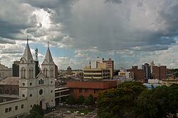
San Antonio de Padua de la Concordia (usually shortened to Concordia) is a city in the north-east of the province of Entre Ríos in the Argentine Mesopotamia. It had about 172,000 inhabitants at the 2001 census , and is the head town of the department of the same name.
Contents
- Slp skateboards tour en concordia entre r os
- Map of Concordia Entre Rios Argentina
- Geography
- Nature
- Transport
- References
Map of Concordia, Entre Rios, Argentina
Geography
Concordia lies on the right-hand (western) shore of the Uruguay River, opposite the city of Salto in Uruguay. The two cities are joined by a road/railway link that is part of the Salto Grande Dam complex (starting on the Argentine side 18 km north from the center of Concordia).
Nature
The city is known as the national capital of citrus production. El Palmar National Park, an important reserve for Yatay palm trees, lies 60 km south of the city.
Transport
The area is served by an airport (IATA: COC, ICAO: SAAC) located at 31°18′S 58°0′W, but which is ostensibly not operational.