
Max. length 25 mi (40 km) Surface elevation 1,280 m Length 40 km | Surface area 9,600 acres (3,900 ha) Area 38.85 km² Catchment area 19,189 km² | |
 | ||
Water volume 709,119 acre·ft (874,685 dam) | ||
Conchas lake state park nm campsite photos
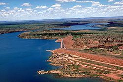
Conchas Lake is a 25-mile (40 km) long reservoir in northeastern New Mexico, behind Conchas Dam on the Canadian River. The lake has an elevation of 4,200 feet (1309.2 meters) and a surface area of 9,600 acres.
Contents
- Conchas lake state park nm campsite photos
- Map of Conchas Lake New Mexico USA
- Conchas lake new mexico bass fishing
- References
Map of Conchas Lake, New Mexico, USA
Conchas Dam was completed in 1939 by the United States Army Corps of Engineers.
Adjacent to the lake is Conchas Lake State Park, which is divided into two separate areas, north and south. The state park has nine public boat ramps: five in the north area and four in the south area. The lake contains walleye, largemouth bass, White bass, Shad, Flathead catfish, channel catfish, bluegill, and crappie. The south area is located between the town of Conchas and Hooverville. Visitors can access the lake via New Mexico State Road 104, at mile marker 75, 29 miles (47 km) northwest of Tucumcari and 75 miles (121 km) southeast of Las Vegas.
Conchas Lake Airport is located on NM 104 east of the lake, and Conchas Lake Seaplane Base is located 2 nautical miles (3.7 km) north of Conchas Dam.