
FIPS code 19-15420 Area 5.67 km² Local time Wednesday 8:16 PM Population 1,886 (2013) | Time zone Central (CST) (UTC-6) GNIS feature ID 0455546 Elevation 184 m Zip code 52738 Area code 319 | |
 | ||
Weather 6°C, Wind N at 6 km/h, 39% Humidity | ||
Columbus Junction is a city in Louisa County, Iowa, United States. The population was 1,899 at the 2010 census. It is part of the Muscatine Micropolitan Statistical Area.
Contents
- Map of Columbus Junction IA 52738 USA
- History
- Geography
- 2010 census
- 2000 census
- Notable residents
- References
Map of Columbus Junction, IA 52738, USA
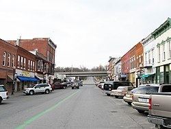
Columbus Junction is home of the historic 'Swinging Bridge' found one block south of Highway 92 near downtown. Columbus Community School District serving Columbus Junction, Columbus City, Fredonia, Cotter, Conesville the surrounding townships is located in Columbus Junction. The city's largest employer is a Tyson pork processing plant located just north of the city on Highway 70.
History
Columbus Junction began as Clifton. The Chicago, Rock Island and Pacific Railroad built an east-west line through the area in 1858, with a station at Clifton. When the north-south Burlington, Cedar Rapids and Minnesota Railway was built, in 1870, it crossed the Rock Island at Clifton. The first BCR&M train arrived on Feb. 7, 1870, and the first local business opened the next day, a restaurant and boarding house, in a building moved by rail from Muscatine, Iowa. Just a month later, the town was platted. Columbus City, Iowa had already been established before the railroads came through, and both the Rock Island and the BCR&M had missed Columbus City by over a mile. As both Columbus City and Township had invested in the latter line, they were permitted to name the new town, so it became Columbus Junction.
Immigration plays a strong role in the history of Columbus Junction. The latest wave of immigrant is refugees from the Chin State of Myanmar (Burma).
In the summer of 2008 the Midwest experienced record floods, Columbus Junction included when the Cedar and Iowa Rivers overflowed their banks.
Geography
Columbus Junction is located at 41°16′42″N 91°21′45″W (41.278414, -91.362466), between the cities of Columbus City and Fredonia. It lies at the confluence of two rivers, the Iowa and the Cedar. The terrain is characterized by hills and ravines which is reflected in a street layout that includes few square blocks and through streets.
According to the United States Census Bureau, the city has a total area of 2.19 square miles (5.67 km2), all of it land.
2010 census
As of the census of 2010, there were 1,899 people, 687 households, and 468 families residing in the city. The population density was 867.1 inhabitants per square mile (334.8/km2). There were 760 housing units at an average density of 347.0 per square mile (134.0/km2). The racial makeup of the city was 74.2% White, 1.6% African American, 0.3% Native American, 3.4% Asian, 17.4% from other races, and 3.0% from two or more races. Hispanic or Latino of any race were 48.0% of the population.
There were 687 households of which 36.4% had children under the age of 18 living with them, 52.3% were married couples living together, 10.0% had a female householder with no husband present, 5.8% had a male householder with no wife present, and 31.9% were non-families. 26.6% of all households were made up of individuals and 9.7% had someone living alone who was 65 years of age or older. The average household size was 2.72 and the average family size was 3.28.
The median age in the city was 35.9 years. 27.1% of residents were under the age of 18; 8.9% were between the ages of 18 and 24; 25.7% were from 25 to 44; 25.3% were from 45 to 64; and 13% were 65 years of age or older. The gender makeup of the city was 51.8% male and 48.2% female.
2000 census
As of the census of 2000, there were 1,900 people, 691 households, and 487 families residing in the city. The population density was 879.6 people per square mile (339.6/km²). There were 748 housing units at an average density of 346.3 per square mile (133.7/km²). The racial makeup of the city was 85.32% White, 0.58% African American, 0.05% Native American, 0.11% Asian, 12.37% from other races, and 1.58% from two or more races. Hispanic or Latino of any race were 39.00% of the population.
There were 691 households out of which 37.2% had children under the age of 18 living with them, 55.3% were married couples living together, 9.3% had a female householder with no husband present, and 29.5% were non-families. 26.3% of all households were made up of individuals and 11.7% had someone living alone who was 65 years of age or older. The average household size was 2.68 and the average family size was 3.24.
28.6% are under the age of 18, 8.9% from 18 to 24, 28.9% from 25 to 44, 19.8% from 45 to 64, and 13.7% who were 65 years of age or older. The median age was 34 years. For every 100 females there were 97.1 males. For every 100 females age 18 and over, there were 91.3 males.
The median income for a household in the city was $33,167, and the median income for a family was $42,188. Males had a median income of $27,841 versus $22,566 for females. The per capita income for the city was $16,314. About 9.7% of families and 11.2% of the population were below the poverty line, including 13.7% of those under age 18 and 8.2% of those age 65 or over.