
West end: SH 93 south of Boulder Length 16.1 km | East end: I-25 in Westminster | |
 | ||
Counties Boulder County, Colorado, Broomfield, Adams County, Colorado | ||
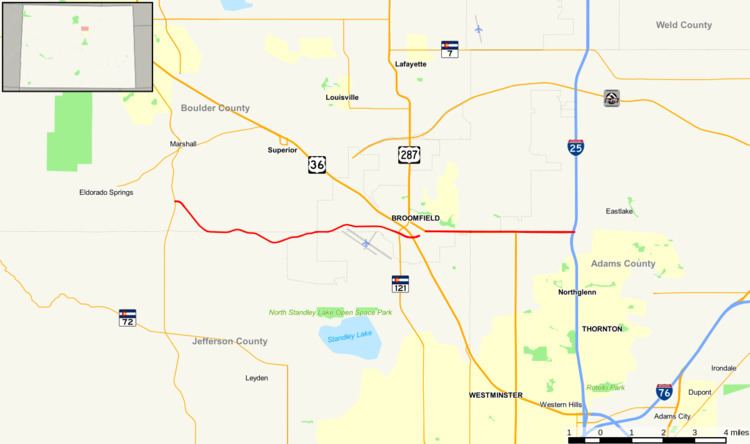
State Highway 128 is a 10 mi (16.1 km) long state highway in the Denver, Colorado metro area.
Contents
Map of CO-128, Colorado, USA
Route description
The route begins in the west at a junction with State Highway 93 roughly thirteen miles south of Boulder. From there, the road proceeds eastward into the northern portions of the Denver metropolitan area. The road passes through portions of the cities of Superior, Broomfield, Northglenn, and Westminster and crosses State Highway 121 before being split by a 3.8 mi (6.1 km) section of concurrency with U.S. Route 287 and again resuming its course towards its eastern terminus at exit 223 of Interstate 25 in the city limits of Westminster.
As of 2016 there is a brief gap of much less than a mile between the junction of SH 128 and SH 121 and the junction of SH 121 and US 287 that is not even nominally part of SH 128. This gap is due to be closed in 2018 by a mile-long connector that began construction in 2009. When construction is complete, the total end-to-end length, including the section that is nominally concurrent with US 287, will be 14 mi (22.5 km).
History
The route was established in the early 1920s, when it began at Federal Boulevard and ended at SH 185 (now deleted). A section from U.S. Route 85 to U.S. Route 6 was added by 1939 and deleted by 1949. The west terminus was extended from U.S. Route 36 to Indiana Street in 1965 and to its current terminus at State Highway 93 two years later.